IMAGES TAKEN NEAR TO
Hood Lane North, WARRINGTON, WA5 1HF
Introduction
This page details the photographs taken nearby to Hood Lane North, WA5 1HF by members of the Geograph project.
The Geograph project started in 2005 with the aim of publishing, organising and preserving representative images for every square kilometre of Great Britain, Ireland and the Isle of Man.

There are currently over 7.5m images from over14,400 individuals and you can help contribute to the project by visiting https://www.geograph.org.uk
Image Map
Images are licensed for reuse under creativecommons.org/licenses/by-sa/2.0
Notes
- Clicking on the map will re-center to the selected point.
- The higher the marker number, the further away the image location is from the centre of the postcode.
Image Listing (4 Images Found)
Images are licensed for reuse under creativecommons.org/licenses/by-sa/2.0
Image
Details
Distance
4
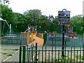
Peace Centre, Warrington
The full name for this building is The Tim Parry Johnathan Ball Young People's Centre after two children were killed in Warrington town centre on March 20th 1993.
Image: © andy
Taken: 25 Jun 2005
0.23 miles