IMAGES TAKEN NEAR TO
Runcorn Road, WARRINGTON, WA4 6UQ
Introduction
This page details the photographs taken nearby to Runcorn Road, WA4 6UQ by members of the Geograph project.
The Geograph project started in 2005 with the aim of publishing, organising and preserving representative images for every square kilometre of Great Britain, Ireland and the Isle of Man.

There are currently over 7.5m images from over14,400 individuals and you can help contribute to the project by visiting https://www.geograph.org.uk
Image Map
Images are licensed for reuse under creativecommons.org/licenses/by-sa/2.0
Notes
- Clicking on the map will re-center to the selected point.
- The higher the marker number, the further away the image location is from the centre of the postcode.
Image Listing (4 Images Found)
Images are licensed for reuse under creativecommons.org/licenses/by-sa/2.0
Image
Details
Distance
1
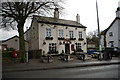
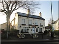
The Red Lion
The Red Lion public house at Moore
Image: © Alexander P Kapp
Taken: 27 Jan 2006
0.16 miles
4
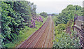
Site of Daresbury station, 1994
View SW from the A508 bridge, towards Frodsham and Chester: ex-Birkenhead Joint (GWR & LNWR) Chester - Warrington - (Manchester) main line. The station was closed 7/7/52, but the line is very much still open. Note the rhododendrons.
Image: © Ben Brooksbank
Taken: 18 Jun 1994
0.23 miles