IMAGES TAKEN NEAR TO
Wilderspool Causeway, WARRINGTON, WA4 6PT
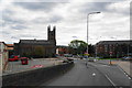
Introduction
This page details the photographs taken nearby to Wilderspool Causeway, WA4 6PT by members of the Geograph project.
The Geograph project started in 2005 with the aim of publishing, organising and preserving representative images for every square kilometre of Great Britain, Ireland and the Isle of Man.

There are currently over 7.5m images from over14,400 individuals and you can help contribute to the project by visiting https://www.geograph.org.uk
Image Map
Images are licensed for reuse under creativecommons.org/licenses/by-sa/2.0
Notes
- Clicking on the map will re-center to the selected point.
- The higher the marker number, the further away the image location is from the centre of the postcode.
Image Listing (81 Images Found)
Images are licensed for reuse under creativecommons.org/licenses/by-sa/2.0
Image
Details
Distance
1
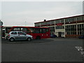
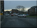
Network Warrington Bus Depot
At Wilderspool Causeway.
Image: © Eirian Evans
Taken: 14 May 2009
0.02 miles
2
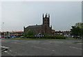
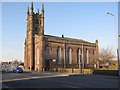
St James's Parish Church, Latchford
On Wilderspool Causeway, near the Bryan Bevan roundabout.
Image: © Eirian Evans
Taken: 14 May 2009
0.03 miles
3
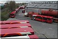
Refuelling at Warrington Bus Depot
Viewed from the road bridge over the railway at Wilderspool Causeway.
Image: © Matt Harrop
Taken: 19 Apr 2015
0.04 miles
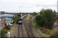
4
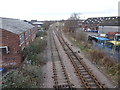
Warrington Wilderspool railway station (site)
Opened in 1853 as a temporary passenger station (pending completion of the bridge over the Mersey, which is behind the camera position), by the Warrington and Stockport Railway, later part of the London & North Western Railway. This single platform station to the right of the line, closed to passengers in 1854 and completely in 1871. No trace remains.
View east towards Latchford and Stockport. The main station for Warrington on this line was at Arpley, also behind the camera position - see Image
For more information, see http://www.disused-stations.org.uk/w/warrington_wilderspool/
Image: © Nigel Thompson
Taken: 28 Jan 2020
0.04 miles
5
St James Church, Latchford
Dominating a roundabout on the A49, with the Network Warrington bus depot to the left.
Image: © Bill Boaden
Taken: 5 Oct 2013
0.05 miles
6
Freight sidings by Bridge Foot Industrial Estate
Looking from a bridge carrying the A49.
Image: © Bill Boaden
Taken: 5 Oct 2013
0.05 miles
7
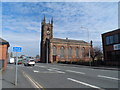
St James' church, Warrington
Built 1829-30 (architect S. Rowland). Re-ordered internally 1897.
Image: © Bikeboy
Taken: 16 Apr 2015
0.05 miles
8
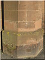
1GL bench mark on St James's Church, Latchford
This First Geodetic Levelling bench mark is on the pillar on the south side of the west door of the church. The church tower has four such pillars, and the mark dates to the period 1851-1852 on the survey line between Warrington and Pembroke Docks. Image
Image: © John S Turner
Taken: 8 Mar 2010
0.06 miles
10
St James's Church, Latchford
Looking across Wilderspool Causeway towards the church of St James. There is a bench mark on the pillar this side of the west door Image
Image: © John S Turner
Taken: 8 Mar 2010
0.06 miles