IMAGES TAKEN NEAR TO
Manx Road, WARRINGTON, WA4 6AL
Introduction
This page details the photographs taken nearby to Manx Road, WA4 6AL by members of the Geograph project.
The Geograph project started in 2005 with the aim of publishing, organising and preserving representative images for every square kilometre of Great Britain, Ireland and the Isle of Man.

There are currently over 7.5m images from over14,400 individuals and you can help contribute to the project by visiting https://www.geograph.org.uk
Image Map
Images are licensed for reuse under creativecommons.org/licenses/by-sa/2.0
Notes
- Clicking on the map will re-center to the selected point.
- The higher the marker number, the further away the image location is from the centre of the postcode.
Image Listing (13 Images Found)
Images are licensed for reuse under creativecommons.org/licenses/by-sa/2.0
Image
Details
Distance

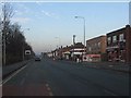
3
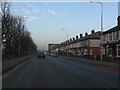
Terraced housing, Chester Road, Warrington
Image: © Peter Whatley
Taken: 17 Jan 2012
0.16 miles

6
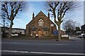
St John's Church, Wilderspool Causeway, Warrington
Image: © Ian S
Taken: 1 Mar 2022
0.18 miles
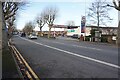
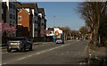
7
Bargain Booze, Chester Road, Warrington
Assorted retailing on Chester Road
Image: © Peter Whatley
Taken: 17 Jan 2012
0.19 miles
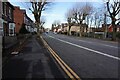
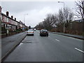
9
Wilderspool Causeway
The A49, Wilderspool Causeway, in Warrington.
Image: © Peter McDermott
Taken: 2 Apr 2021
0.22 miles
10
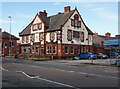
The Causeway public house, Wilderspool Causeway, Warrington
Image: © Ian S
Taken: 1 Mar 2022
0.22 miles