IMAGES TAKEN NEAR TO
Normans Lane, WARRINGTON, WA4 4PY
Introduction
This page details the photographs taken nearby to Normans Lane, WA4 4PY by members of the Geograph project.
The Geograph project started in 2005 with the aim of publishing, organising and preserving representative images for every square kilometre of Great Britain, Ireland and the Isle of Man.

There are currently over 7.5m images from over14,400 individuals and you can help contribute to the project by visiting https://www.geograph.org.uk
Image Map
Images are licensed for reuse under creativecommons.org/licenses/by-sa/2.0
Notes
- Clicking on the map will re-center to the selected point.
- The higher the marker number, the further away the image location is from the centre of the postcode.
Image Listing (8 Images Found)
Images are licensed for reuse under creativecommons.org/licenses/by-sa/2.0
Image
Details
Distance
2
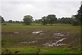
Field, near Higher Whitley
Wet, during a long period of heavy rainfall, including the following Winter.
Image: © Richard Webb
Taken: 7 Oct 2017
0.09 miles
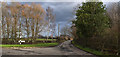
5
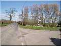
Junction of Lake Lane & Bentley's Farm Lane, Higher Whitley
Looking North East
Image: © Ian Warburton
Taken: 16 Apr 2006
0.15 miles
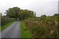
6
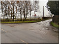
Lake Lane
The junction of Lake Lane with Bentley's Farm Lane at Bentley's Farm, Higher Whitley.
Image: © David Dixon
Taken: 25 Feb 2010
0.20 miles
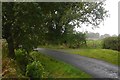
7
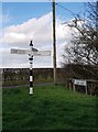
Direction Sign ? Signpost
Located on the northeast side of the junction of Bentleys Farm Lane and Lake Lane in Whitley parish. 3 arms and pawn finial.
Milestone Society National ID: CH_SJ6280
Image: © T Maestri
Taken: 16 Feb 2019
0.20 miles