IMAGES TAKEN NEAR TO
Northwich Road, WARRINGTON, WA4 4PN
Introduction
This page details the photographs taken nearby to Northwich Road, WA4 4PN by members of the Geograph project.
The Geograph project started in 2005 with the aim of publishing, organising and preserving representative images for every square kilometre of Great Britain, Ireland and the Isle of Man.

There are currently over 7.5m images from over14,400 individuals and you can help contribute to the project by visiting https://www.geograph.org.uk
Image Map
Images are licensed for reuse under creativecommons.org/licenses/by-sa/2.0
Notes
- Clicking on the map will re-center to the selected point.
- The higher the marker number, the further away the image location is from the centre of the postcode.
Image Listing (8 Images Found)
Images are licensed for reuse under creativecommons.org/licenses/by-sa/2.0
Image
Details
Distance
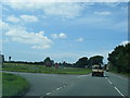
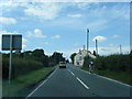
3
Road junction A559
Knutsford Road heads off east from the A559. I couldn't find the nearby trig pillar so this piece of road will have to suffice as the representative image. It was raining and I was a bit fed up. Sorry. Eureka, it's been included on the site by another contributor Image]
Image: © michael ely
Taken: 6 Apr 2006
0.09 miles
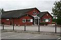
5
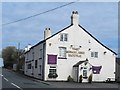
The Birch and Bottle
Seems to a Chinese restaurant rather than a pub.
Image: © Bikeboy
Taken: 16 Apr 2015
0.22 miles