IMAGES TAKEN NEAR TO
Daresbury Park, WARRINGTON, WA4 4HS
Introduction
This page details the photographs taken nearby to Daresbury Park, WA4 4HS by members of the Geograph project.
The Geograph project started in 2005 with the aim of publishing, organising and preserving representative images for every square kilometre of Great Britain, Ireland and the Isle of Man.

There are currently over 7.5m images from over14,400 individuals and you can help contribute to the project by visiting https://www.geograph.org.uk
Image Map
Images are licensed for reuse under creativecommons.org/licenses/by-sa/2.0
Notes
- Clicking on the map will re-center to the selected point.
- The higher the marker number, the further away the image location is from the centre of the postcode.
Image Listing (9 Images Found)
Images are licensed for reuse under creativecommons.org/licenses/by-sa/2.0
Image
Details
Distance
1

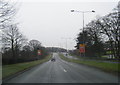
A field entrance at Red Brow
With the ubiquitous Fiddler's Ferry Power Station in view
Image: © Ian Greig
Taken: 19 Apr 2013
0.08 miles

5
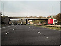
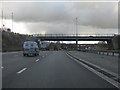
M56, Junction 11
Bridge carrying the A56 over the M56 at Junction 11. (The other half of the A56 roundabout is on the second bridge which can just be seen through the one in the foreground.)
Image: © David Dixon
Taken: 9 Nov 2010
0.13 miles
7
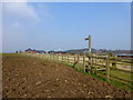
Waymarker on Red Brow Lane, Daresbury Park
Image: © Raymond Knapman
Taken: 19 Mar 2015
0.17 miles