IMAGES TAKEN NEAR TO
Street Lane, WARRINGTON, WA4 4EN
Introduction
This page details the photographs taken nearby to Street Lane, WA4 4EN by members of the Geograph project.
The Geograph project started in 2005 with the aim of publishing, organising and preserving representative images for every square kilometre of Great Britain, Ireland and the Isle of Man.

There are currently over 7.5m images from over14,400 individuals and you can help contribute to the project by visiting https://www.geograph.org.uk
Image Map
Images are licensed for reuse under creativecommons.org/licenses/by-sa/2.0
Notes
- Clicking on the map will re-center to the selected point.
- The higher the marker number, the further away the image location is from the centre of the postcode.
Image Listing (14 Images Found)
Images are licensed for reuse under creativecommons.org/licenses/by-sa/2.0
Image
Details
Distance
3
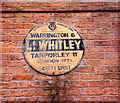
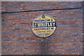
Old AA Sign on Street Lane, Lower Whitley
Old AA Sign located on the brick wall of a converted barn on the east side of Street Lane in Lower Whitley, 5 miles northwest of Northwich. Whitley parish.
This is the Circular, village name on black band, no Motor Union symbol or name type, dating from 1923, showing distances Warrington 6 Tarporley 11 London 177½.
There were five series of AA signs, mostly dating from 1923 and made by Francis & Co / Franco in Deptford, London. The village name and distance to London or Dublin were normally displayed.
See also https://www.geograph.org.uk/photo/1110760 and https://www.geograph.org.uk/photo/1110772.
Milestone Society National ID: CH-LWHIT
Image: © Milestone Society
Taken: Unknown
0.02 miles
5
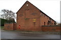
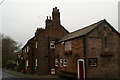
Converted barn, Chetwode Farm, Lower Whitley
Note the old Automobile Association sign on the gable end.
Image: © David Long
Taken: 7 Jan 2009
0.03 miles
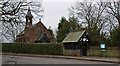
6
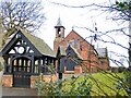
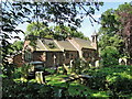
St. Luke's Church, Whitley
Church and Lychgate at Lower Whitley.
Image: © Roger May
Taken: 6 Mar 2006
0.04 miles
7
Automobile Association sign on the old A49
Before the motorways, the A49 was the major link from Liverpool, Warrington and South-West Lancashire to the A5 road to London. The sign has survived, and may be seen on the gable end of the barn opposite the entrance to the Chetwode Arms.
Image: © David Long
Taken: 7 Jan 2009
0.04 miles
10
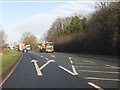
A49 approaching the junction for Lower Whitley
The A49 now forms a brief bypass around the village.
Image: © Peter Whatley
Taken: 17 Jan 2012
0.08 miles