IMAGES TAKEN NEAR TO
Village Lane, WARRINGTON, WA4 4EJ
Introduction
This page details the photographs taken nearby to Village Lane, WA4 4EJ by members of the Geograph project.
The Geograph project started in 2005 with the aim of publishing, organising and preserving representative images for every square kilometre of Great Britain, Ireland and the Isle of Man.

There are currently over 7.5m images from over14,400 individuals and you can help contribute to the project by visiting https://www.geograph.org.uk
Image Map
Images are licensed for reuse under creativecommons.org/licenses/by-sa/2.0
Notes
- Clicking on the map will re-center to the selected point.
- The higher the marker number, the further away the image location is from the centre of the postcode.
Image Listing (6 Images Found)
Images are licensed for reuse under creativecommons.org/licenses/by-sa/2.0
Image
Details
Distance
1
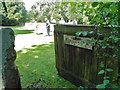
Quaker Burial Ground
Gate to the burial ground
Image: © Tim Evans
Taken: 14 Jun 2011
0.13 miles
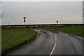
3
A49 at Street Lane junction
The northern end of curiously named Street Lane which is the original A49 route through Lower Whitley.
Image: © Peter Whatley
Taken: 17 Jan 2012
0.22 miles
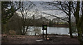
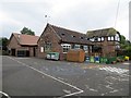
4
Old meets new
The village of Lower Whitley was on the A49 itself, until a by-pass was built to the west of it.
Image: © David Long
Taken: 7 Jan 2009
0.23 miles
5
Whitley Village School
Primary school, Higher Whitley.
Image: © Richard Webb
Taken: 28 Jun 2014
0.23 miles
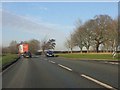
6

HGV on Tarporley Road
A Scania S143 (N336 FKW) travelling northwards along the A49 near Whitley.
Image: © David Dixon
Taken: 11 Apr 2016
0.23 miles