IMAGES TAKEN NEAR TO
Tarporley Road, WARRINGTON, WA4 4DS
Introduction
This page details the photographs taken nearby to Tarporley Road, WA4 4DS by members of the Geograph project.
The Geograph project started in 2005 with the aim of publishing, organising and preserving representative images for every square kilometre of Great Britain, Ireland and the Isle of Man.

There are currently over 7.5m images from over14,400 individuals and you can help contribute to the project by visiting https://www.geograph.org.uk
Image Map
Images are licensed for reuse under creativecommons.org/licenses/by-sa/2.0
Notes
- Clicking on the map will re-center to the selected point.
- The higher the marker number, the further away the image location is from the centre of the postcode.
Image Listing (16 Images Found)
Images are licensed for reuse under creativecommons.org/licenses/by-sa/2.0
Image
Details
Distance
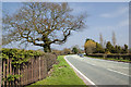
2
A49 Tarporley Road Passing Brookside Fisheries
Image: © David Dixon
Taken: 11 Apr 2016
0.07 miles
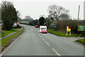
3
Welcome to Warrington on the A49
Entrance to the greatly extended boundary of Warrington, before 1974 firmly located only on the Lancashire side of the Manchester Ship Canal.
Image: © Peter Whatley
Taken: 17 Jan 2012
0.10 miles
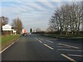
5
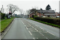
A49 Approaching Crossroads at Chapelhouse Farm
Image: © David Dixon
Taken: 11 Apr 2016
0.17 miles
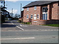
6
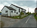
Pillmoss Lane at Whitley Methodist Chapel
Image: © Alexander P Kapp
Taken: 2 May 2012
0.19 miles
7
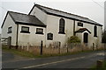
Whitley Methodist Church
The date on the name plate is 1802.
Image: © David Long
Taken: 7 Jan 2009
0.19 miles
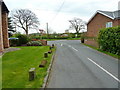
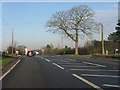
9
Junction of Pillmoss Lane & Tarporley Road (A49)
Image: © Ian Warburton
Taken: 16 Apr 2006
0.19 miles
10
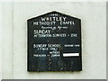
Whitley Methodist Chapel, Nameboard
Image: © Alexander P Kapp
Taken: 2 May 2012
0.19 miles