IMAGES TAKEN NEAR TO
Cottons Bridge, WARRINGTON, WA4 4AX
Introduction
This page details the photographs taken nearby to Cottons Bridge, WA4 4AX by members of the Geograph project.
The Geograph project started in 2005 with the aim of publishing, organising and preserving representative images for every square kilometre of Great Britain, Ireland and the Isle of Man.

There are currently over 7.5m images from over14,400 individuals and you can help contribute to the project by visiting https://www.geograph.org.uk
Image Map
Images are licensed for reuse under creativecommons.org/licenses/by-sa/2.0
Notes
- Clicking on the map will re-center to the selected point.
- The higher the marker number, the further away the image location is from the centre of the postcode.
Image Listing (50 Images Found)
Images are licensed for reuse under creativecommons.org/licenses/by-sa/2.0
Image
Details
Distance
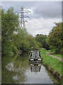
1
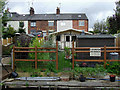
Terraced housing near Preston Brook, Cheshire
The road is called Cotton's Bridge, and these canalside properties include a pooch parlour!
Image: © Roger D Kidd
Taken: 29 Aug 2011
0.01 miles
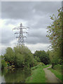
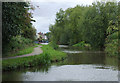
2
The Bridgewater Canal near Preston Brook, Cheshire
The Bridgewater Canal was opened in stages between 1761 and 1795, mainly for the purpose of carrying coal. It continued to carry commercial traffic until 1974. This telephoto assisted image does exaggerate the droop of the power cables.
Image: © Roger D Kidd
Taken: 29 Aug 2011
0.02 miles
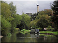
3
The Bridgewater Canal near Preston Brook, Cheshire
The Bridgewater Canal was opened in stages between 1761 and 1795, mainly for the purpose of carrying coal. It continued to carry commercial traffic until 1974.
David Dixon's article is worth exploring:
Image: © Roger D Kidd
Taken: 29 Aug 2011
0.02 miles
4
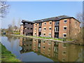
Converted Warehouse
Trent and Mersey Canal, north of Preston Brook Tunnel. Appears to be a conversion of a former canal transhipment warehouse
Image: © Mike Todd
Taken: 16 May 2011
0.03 miles
5
The Bridgewater Canal near Preston Brook, Cheshire
This is the link between the Trent and Mersey Canal at Preston Brook Tunnel and the main line between Manchester and Runcorn.
David Dixon writes:
Image: © Roger D Kidd
Taken: 29 Aug 2011
0.04 miles
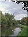
6
The Bridgewater Canal near Preston Brook, Cheshire
The Bridgewater Canal was opened in stages between 1761 and 1795, mainly for the purpose of carrying coal. It continued to carry commercial traffic until 1974.
Image: © Roger D Kidd
Taken: 29 Aug 2011
0.04 miles
7
Bridgewater canal towards Preston Brook Tunnel
Image: © Ian S
Taken: 29 Jan 2022
0.04 miles
8
The Bridgewater Canal near Preston Brook, Cheshire
Looking south towards Preston Brook Tunnel.
Notes by David Dixon:
Image: © Roger D Kidd
Taken: 29 Aug 2011
0.06 miles
9
Canal warehouse conversion
I recall that the old warehouse was used as a nightclub called Neptune Moorings in the 1960's
Image: © Raymond Knapman
Taken: 19 Mar 2015
0.09 miles
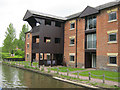
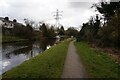
10
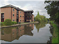
Canal and apartments at Preston Brook, Cheshire
The apartments are in a Grade II listed former warehouse.
The Wooden Canal Boat Society website reports in 1998 that: "The North Staffordshire Warehouse at Preston Brook still stands empty. It used to be the Old Number One pub and night club until it burned down. As a listed building it has now been rebuilt and is being advertised as offices, but has been empty for several years." http://www.wcbs.org.uk/old-news/southams-journey-from-runcorn-to-ashton
The Bridgewater Canal was opened in stages between 1761 and 1776. It continued to carry commercial traffic until 1974. David Dixon has provided this extra information:
Image: © Roger D Kidd
Taken: 29 Aug 2011
0.09 miles