IMAGES TAKEN NEAR TO
Reynolds Street, WARRINGTON, WA4 1TT
Introduction
This page details the photographs taken nearby to Reynolds Street, WA4 1TT by members of the Geograph project.
The Geograph project started in 2005 with the aim of publishing, organising and preserving representative images for every square kilometre of Great Britain, Ireland and the Isle of Man.

There are currently over 7.5m images from over14,400 individuals and you can help contribute to the project by visiting https://www.geograph.org.uk
Image Map
Images are licensed for reuse under creativecommons.org/licenses/by-sa/2.0
Notes
- Clicking on the map will re-center to the selected point.
- The higher the marker number, the further away the image location is from the centre of the postcode.
Image Listing (5 Images Found)
Images are licensed for reuse under creativecommons.org/licenses/by-sa/2.0
Image
Details
Distance
1
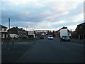
Nook Lane looking to Latchford Bridge, long disused
Image: © Colin Pyle
Taken: 4 Apr 2013
0.19 miles
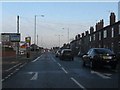
3
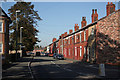
Thelwall Lane
Victorian terraced housing near Latchford Locks.
Image: © Alan Murray-Rust
Taken: 6 Oct 2008
0.22 miles
4
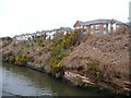
Clearwater Quays
New housing development on the north bank of the Manchester Ship Canal.
Image: © Christine Johnstone
Taken: 13 Apr 2013
0.24 miles
5
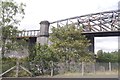
Latchford Viaduct
A high railway bridge over the Manchester Ship Canal with the same engineers as the Forth Bridge, Arrol. Closed in 1985 because of maintenance and renovation costs. At the time there was even talk of closing Arrol's best known construction The Forth Bridge.
Today it is closed to all traffic and the Trans Pennine Trail uses the B5157.
Image: © Richard Webb
Taken: 11 Aug 2019
0.24 miles