IMAGES TAKEN NEAR TO
Powell Street, WARRINGTON, WA4 1LA
Introduction
This page details the photographs taken nearby to Powell Street, WA4 1LA by members of the Geograph project.
The Geograph project started in 2005 with the aim of publishing, organising and preserving representative images for every square kilometre of Great Britain, Ireland and the Isle of Man.

There are currently over 7.5m images from over14,400 individuals and you can help contribute to the project by visiting https://www.geograph.org.uk
Image Map
Images are licensed for reuse under creativecommons.org/licenses/by-sa/2.0
Notes
- Clicking on the map will re-center to the selected point.
- The higher the marker number, the further away the image location is from the centre of the postcode.
Image Listing (44 Images Found)
Images are licensed for reuse under creativecommons.org/licenses/by-sa/2.0
Image
Details
Distance
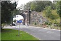
3
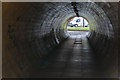
The pedestrian tunnel under the railway embankment
Image: © Ian Greig
Taken: 3 May 2013
0.07 miles
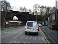
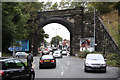
4
Knutsford Road, Warrington
Passing under what was a railway until 1985.
Image: © Richard Webb
Taken: 11 Aug 2019
0.07 miles
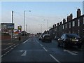
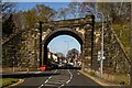
5
Knutsford Road
Morning traffic and disused railway bridge on Knutsford Road
Image: © Richard Croft
Taken: 10 Sep 2010
0.08 miles
7
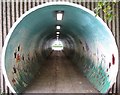
Pedestrian tunnel under the railway embankment
Image: © Sue Adair
Taken: 3 Nov 2019
0.08 miles

9
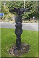
Millennium milepost, Knutsford Road
A signpost on route 62 of the National Cycle Network near the swing bridge.
Image: © Richard Webb
Taken: 11 Aug 2019
0.10 miles