IMAGES TAKEN NEAR TO
Beatrice Street, WA4 1DY
Introduction
This page details the photographs taken nearby to Beatrice Street, WA4 1DY by members of the Geograph project.
The Geograph project started in 2005 with the aim of publishing, organising and preserving representative images for every square kilometre of Great Britain, Ireland and the Isle of Man.

There are currently over 7.5m images from over14,400 individuals and you can help contribute to the project by visiting https://www.geograph.org.uk
Image Map
Images are licensed for reuse under creativecommons.org/licenses/by-sa/2.0
Notes
- Clicking on the map will re-center to the selected point.
- The higher the marker number, the further away the image location is from the centre of the postcode.
Image Listing (15 Images Found)
Images are licensed for reuse under creativecommons.org/licenses/by-sa/2.0
Image
Details
Distance
1
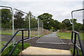
An entrance to Victoria Park
Quite a large area is fenced off though there is no obvious activity being undertaken within the fence. At this point it has fallen over completely.
Image: © Bill Boaden
Taken: 5 Oct 2013
0.06 miles
2
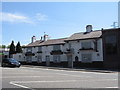
The Black Bear, Knutsford Road
The name Latchford means "ford over the Laecc or stream", in this case, the River Mersey, crossed at this point by a ford before the first wooden bridge was built. Its location is just to the east of Black Bear Bridge, the Mersey was later diverted for the industrial revolution in Warrington.
Image: © Sue Adair
Taken: 8 Jun 2008
0.14 miles
3
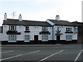
Black Bear, Knutsford Road
Converted to offices
Image: © Alex McGregor
Taken: 16 Jun 2010
0.14 miles
6
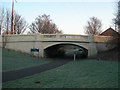
Black Bear Bridge
This bridge carries the A5061 (Knutsford Road) over this Linear Park (fancy name for a footpath!) was originally built to cross a canal from the Manor Lock on the River Mersey up at the Kingsway Bridge down to the Manchester Ship Canal at the Stockton Heath Swing Bridge.
Image: © Mike Lyne
Taken: 3 Feb 2012
0.16 miles
7
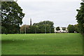
Victoria Park, Warrington
The original hall is now a restaurant. The spire belongs to St Elphin's Church on the other side of the Mersey.
Image: © Bill Boaden
Taken: 5 Oct 2013
0.17 miles
8
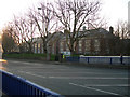
Richard Fairclough House
The Environment Agency's Richard Fairclough House on the A5061, Knutsford Road. The entrance and exit is in the adjacent Wash Lane.
Image: © Mike Lyne
Taken: 3 Feb 2012
0.17 miles
9
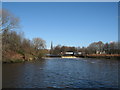
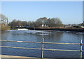
River Mersey at Latchford
Weir on the River Mersey at Latchford near Victoria Park. Photograph taken from Knutsford Road.
Image: © Sue Adair
Taken: 4 Mar 2008
0.18 miles
10
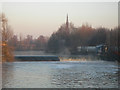
The Weir on the Mersey
The Weir on the Mersey between Howley and Victoria Park. Photo taken from the A5061 Knutsford Road on a cold and frosty morning and you can see the mist rising off the water in the early morning sunshine.
Image: © Mike Lyne
Taken: 3 Feb 2012
0.19 miles