IMAGES TAKEN NEAR TO
Knutsford Road, WARRINGTON, WA4 1AB
Introduction
This page details the photographs taken nearby to Knutsford Road, WA4 1AB by members of the Geograph project.
The Geograph project started in 2005 with the aim of publishing, organising and preserving representative images for every square kilometre of Great Britain, Ireland and the Isle of Man.

There are currently over 7.5m images from over14,400 individuals and you can help contribute to the project by visiting https://www.geograph.org.uk
Image Map
Images are licensed for reuse under creativecommons.org/licenses/by-sa/2.0
Notes
- Clicking on the map will re-center to the selected point.
- The higher the marker number, the further away the image location is from the centre of the postcode.
Image Listing (95 Images Found)
Images are licensed for reuse under creativecommons.org/licenses/by-sa/2.0
Image
Details
Distance
1
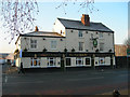
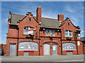
The Royal Oak Branch pub
The Royal Oak Branch pub on the A5061 Knutsford Road very close to the roundabout at Bridgefoot.
Image: © Mike Lyne
Taken: 3 Feb 2012
0.04 miles
3
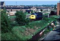
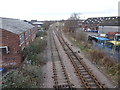
Running round at Latchford sidings
40150 runs round a tank train at Warrington Latchford sidings. The former freight line to Stockport via Lym can be seen in the background. This shut around the end of 1984.
Image: © roger geach
Taken: 8 Jun 1984
0.06 miles
4
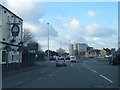
A5061 Knutsford Road at The Royal Oak Branch
Image: © Colin Pyle
Taken: 30 Jan 2016
0.07 miles
5
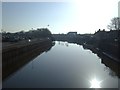
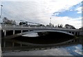
Warrington Wilderspool railway station (site)
Opened in 1853 as a temporary passenger station (pending completion of the bridge over the Mersey, which is behind the camera position), by the Warrington and Stockport Railway, later part of the London & North Western Railway. This single platform station to the right of the line, closed to passengers in 1854 and completely in 1871. No trace remains.
View east towards Latchford and Stockport. The main station for Warrington on this line was at Arpley, also behind the camera position - see Image
For more information, see http://www.disused-stations.org.uk/w/warrington_wilderspool/
Image: © Nigel Thompson
Taken: 28 Jan 2020
0.09 miles
9
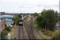
Freight sidings by Bridge Foot Industrial Estate
Looking from a bridge carrying the A49.
Image: © Bill Boaden
Taken: 5 Oct 2013
0.10 miles
10
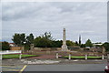
War memorial at Warrington
In a garden next to the Mersey. The spire of St Elphin's Church is behind.
Image: © Bill Boaden
Taken: 5 Oct 2013
0.10 miles