IMAGES TAKEN NEAR TO
Arkenshaw Road, WARRINGTON, WA3 7HL
Introduction
This page details the photographs taken nearby to Arkenshaw Road, WA3 7HL by members of the Geograph project.
The Geograph project started in 2005 with the aim of publishing, organising and preserving representative images for every square kilometre of Great Britain, Ireland and the Isle of Man.

There are currently over 7.5m images from over14,400 individuals and you can help contribute to the project by visiting https://www.geograph.org.uk
Image Map
Images are licensed for reuse under creativecommons.org/licenses/by-sa/2.0
Notes
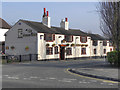
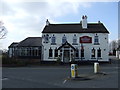
- Clicking on the map will re-center to the selected point.
- The higher the marker number, the further away the image location is from the centre of the postcode.
Image Listing (25 Images Found)
Images are licensed for reuse under creativecommons.org/licenses/by-sa/2.0
Image
Details
Distance
2
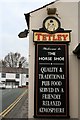
Sign on The Horse Shoe
Still with the old Tetley Huntsman.
Image: © David Lally
Taken: 16 Apr 2010
0.09 miles

5
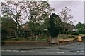
Croft, Graveyard on the corner of Lady Lane and New Lane
Image: © michelle grose
Taken: 27 May 2006
0.11 miles
8
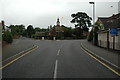
Road Junction, Croft
This is the junction of Lord Street, Heath Lane and Mustard Lane, Croft, near Warrington.
Image: © andy
Taken: 22 Jul 2005
0.15 miles
9
The General Elliot Public House - Croft
Image: © Anthony Parkes
Taken: 24 Oct 2011
0.15 miles
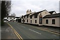
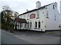
10
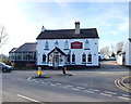
The General Elliot
At the junction of Mustard Lane and Heath Lane
Image: © Gary Rogers
Taken: 14 Feb 2019
0.15 miles