IMAGES TAKEN NEAR TO
Sandy Brow Lane, WARRINGTON, WA3 7EB
Introduction
This page details the photographs taken nearby to Sandy Brow Lane, WA3 7EB by members of the Geograph project.
The Geograph project started in 2005 with the aim of publishing, organising and preserving representative images for every square kilometre of Great Britain, Ireland and the Isle of Man.

There are currently over 7.5m images from over14,400 individuals and you can help contribute to the project by visiting https://www.geograph.org.uk
Image Map
Images are licensed for reuse under creativecommons.org/licenses/by-sa/2.0
Notes
- Clicking on the map will re-center to the selected point.
- The higher the marker number, the further away the image location is from the centre of the postcode.
Image Listing (11 Images Found)
Images are licensed for reuse under creativecommons.org/licenses/by-sa/2.0
Image
Details
Distance
4
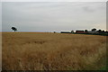
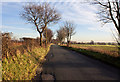
View across farm land near Croft
This is a view looking south west over farm land. Taken from Stone Pit Lane near Croft, Warrington. Right in the centre of this photograph, if you look very hard, is Fiddlers Ferry Power Station which is around 12km away (it was at least visible on the six megapixel original anyway).
Image: © andy
Taken: 27 Jul 2005
0.17 miles
5
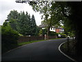
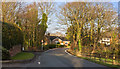
Sandy Brow Lane at Croft village boundary
Image: © Colin Pyle
Taken: 12 Jul 2016
0.17 miles
7
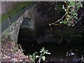
Cockshot Brook
Cockshot Brook passing under Stone Pit Lane near Kenyon. SJ62469482.
Image: © Keith Williamson
Taken: 26 Sep 2005
0.19 miles
9
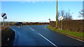
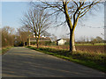
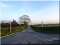
Junction of Sandy Brow Lane with Winwick Lane
Image: © Richard Cooke
Taken: 16 Dec 2019
0.20 miles
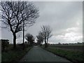
10
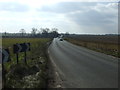
Winwick Lane (A579), heading south
Towards the M6.
Image: © JThomas
Taken: 2 Mar 2013
0.22 miles