IMAGES TAKEN NEAR TO
Heath Lane, WARRINGTON, WA3 7DP
Introduction
This page details the photographs taken nearby to Heath Lane, WA3 7DP by members of the Geograph project.
The Geograph project started in 2005 with the aim of publishing, organising and preserving representative images for every square kilometre of Great Britain, Ireland and the Isle of Man.

There are currently over 7.5m images from over14,400 individuals and you can help contribute to the project by visiting https://www.geograph.org.uk
Image Map
Images are licensed for reuse under creativecommons.org/licenses/by-sa/2.0
Notes
- Clicking on the map will re-center to the selected point.
- The higher the marker number, the further away the image location is from the centre of the postcode.
Image Listing (10 Images Found)
Images are licensed for reuse under creativecommons.org/licenses/by-sa/2.0
Image
Details
Distance
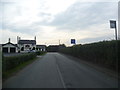
3
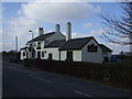
The Plough
The Plough Inn at New Lane End
Image: © David Dixon
Taken: 24 Mar 2012
0.17 miles
4
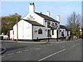
The Plough, at Junction of Stone Pit Lane & Kenyon Lane
Image: © Richard Cooke
Taken: 16 Dec 2019
0.17 miles
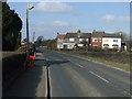
6
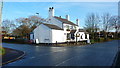
Approaching the Plough Inn on Kenyon Lane
Image: © Anthony Parkes
Taken: 24 Oct 2011
0.17 miles
9
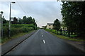
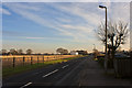
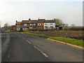
Heath Lane, Croft
This is a view looking north down Heath Lane as it runs from Croft to New Lane End.
Image: © andy
Taken: 29 Jul 2005
0.24 miles
10
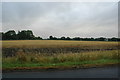
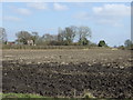
Farm land, Croft
This is a view looking west across farm land just to the north of Croft. Nestled in the trees to the left is Kenyon Farm.
Image: © andy
Taken: 29 Jul 2005
0.24 miles