IMAGES TAKEN NEAR TO
Dam Head Lane, WARRINGTON, WA3 6LF
Introduction
This page details the photographs taken nearby to Dam Head Lane, WA3 6LF by members of the Geograph project.
The Geograph project started in 2005 with the aim of publishing, organising and preserving representative images for every square kilometre of Great Britain, Ireland and the Isle of Man.

There are currently over 7.5m images from over14,400 individuals and you can help contribute to the project by visiting https://www.geograph.org.uk
Image Map
Images are licensed for reuse under creativecommons.org/licenses/by-sa/2.0
Notes
- Clicking on the map will re-center to the selected point.
- The higher the marker number, the further away the image location is from the centre of the postcode.
Image Listing (20 Images Found)
Images are licensed for reuse under creativecommons.org/licenses/by-sa/2.0
Image
Details
Distance
1
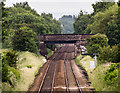
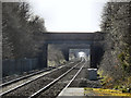
Manchester to Liverpool Railway
Bridge carrying Dam Head Lane over the Manchester to Liverpool Railway.
Image: © Peter McDermott
Taken: 14 Jun 2017
0.04 miles
3
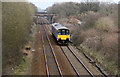
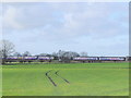
CLC main line looking east from Dam Head Lane
The Cheshire Lines Committee was a grouping of the Manchester, Sheffield & Lincolnshire (later Great Central), Great Northern and Midland Railways primarily developed to allow these companies direct access to Liverpool docks.
The principal line ran between Manchester and Liverpool and is today a main passenger corridor between the two cities. This class 158 unit on its way to Liverpool is passing the site of Glazebrook West Junction where a branch to St Helen's and Wigan (owned solely by the MSLR) diverged to the left of the picture. There is today little trace of the junction.
Image: © Alan Murray-Rust
Taken: 8 Apr 2013
0.09 miles

5
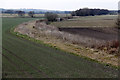
Trackbed of the Wigan branch
The Great Central Railway, one of the constituent companies of the Cheshire Lines Committee, operated its own branch off the CLC main line at Glazebrook to serve the mining areas up to St Helens and Wigan. Although originally proposed by the CLC, the other two constituents were not interested, and the GCR went it alone.
There was a triangular junction allowing the branch to be accessed from both the Liverpool and Manchester directions. In the foreground is the eastern curve, with the western leg being marked by the bank with two trees to the left hand side of the picture. The branch (latterly serving Wigan only) closed to passengers in 1964 and freight in 1968.
Image: © Alan Murray-Rust
Taken: 8 Apr 2013
0.11 miles


8
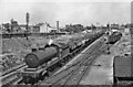
Westbound coal train at Glazebrook
View eastward on the Cheshire Lines (CLC) main line, Manchester/Stockport - Liverpool. The Class J train of power-station coal from Yorkshire is headed by Thomson O4/8 rebuild of a Robinson ex-Great Central 2-8-0, No. 63721. Glazebrook station is in the distance.
Image: © Ben Brooksbank
Taken: 21 Jun 1957
0.15 miles
10
Bridges
Looking west from Glazebrook Station. The first bridge is Bank Street, the second is Dam Head Lane, the third is Dam Lane Image
Image: © David Dixon
Taken: 18 Mar 2011
0.17 miles