IMAGES TAKEN NEAR TO
Dam Lane, WARRINGTON, WA3 6LE
Introduction
This page details the photographs taken nearby to Dam Lane, WA3 6LE by members of the Geograph project.
The Geograph project started in 2005 with the aim of publishing, organising and preserving representative images for every square kilometre of Great Britain, Ireland and the Isle of Man.

There are currently over 7.5m images from over14,400 individuals and you can help contribute to the project by visiting https://www.geograph.org.uk
Image Map
Images are licensed for reuse under creativecommons.org/licenses/by-sa/2.0
Notes
- Clicking on the map will re-center to the selected point.
- The higher the marker number, the further away the image location is from the centre of the postcode.
Image Listing (16 Images Found)
Images are licensed for reuse under creativecommons.org/licenses/by-sa/2.0
Image
Details
Distance
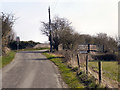
1
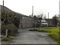
Dam Lane
The junction of Dam Lane and Dam Head Lane. Hollingreave Farm is on the left.
Image: © David Dixon
Taken: 24 Mar 2011
0.13 miles
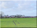
2
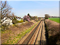
Glazebrook Moss
Looking east, from the bridge at Dam Lane, along the railway across Glazebrook Moss.
Image: © David Dixon
Taken: 28 Mar 2011
0.13 miles
4
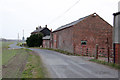
Hollingreave Farm
On Dam Lane near Glazebrook. Typical 19th century farmhouse and outbuildings, in almost fen-like countryside.
Image: © Alan Murray-Rust
Taken: 8 Apr 2013
0.14 miles
5
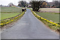
Dam Head Lane with daffodil hedges
Someone - surely not the local authority - has gone to a lot of trouble and expense to provide this display of miniature daffodils.
Image: © Alan Murray-Rust
Taken: 8 Apr 2013
0.14 miles
7
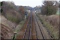
Site of Dam Lane Junction
The actual junction was between the steps and the signal on the left hand side. It was the start of the western chord of a triangular junction between the Cheshire Lines Committee main Manchester to Liverpool line (seen here) and the Great Central Railway branch to Wigan Central and St Helens Central Stations. The other side of the triangle joined beyond the next bridge, see http://www.geograph.org.uk/photo/3411238
Image: © Alan Murray-Rust
Taken: 8 Apr 2013
0.18 miles
8
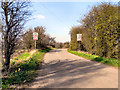
Dam Lane
Approaching the bridge over the railway.
Image: © David Dixon
Taken: 28 Mar 2011
0.19 miles
9
School Lane
School Lane, approaching the bridge (Dam Lane) across the railway at Glazebrook Moss.
Image: © David Dixon
Taken: 28 Mar 2011
0.19 miles
10
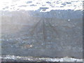
Ordnance Survey Cut Mark with Pivot
This can be found on Hollingreave Railway Bridge parapet.
For more detail see : http://www.bench-marks.org.uk/bm45955
Image: © Peter Wood
Taken: 27 Oct 2012
0.19 miles