IMAGES TAKEN NEAR TO
Nicol Avenue, WARRINGTON, WA3 6DN
Introduction
This page details the photographs taken nearby to Nicol Avenue, WA3 6DN by members of the Geograph project.
The Geograph project started in 2005 with the aim of publishing, organising and preserving representative images for every square kilometre of Great Britain, Ireland and the Isle of Man.

There are currently over 7.5m images from over14,400 individuals and you can help contribute to the project by visiting https://www.geograph.org.uk
Image Map
Images are licensed for reuse under creativecommons.org/licenses/by-sa/2.0
Notes
- Clicking on the map will re-center to the selected point.
- The higher the marker number, the further away the image location is from the centre of the postcode.
Image Listing (16 Images Found)
Images are licensed for reuse under creativecommons.org/licenses/by-sa/2.0
Image
Details
Distance
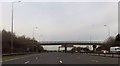
1
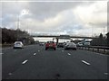
M6 Motorway - Moss Avenue bridge, Woolston Moss
Image: © Peter Whatley
Taken: 18 Jan 2011
0.08 miles
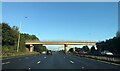
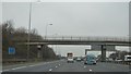
6
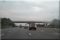
M6, Woolston Moss
Bridge carrying Nicol Avenue over vthe M6; providing access to Brookfield Farm and Moss Brow Cottages.
Image: © David Dixon
Taken: 4 Sep 2010
0.10 miles
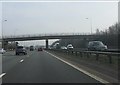
7
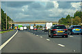
Woolston : M6 Motorway
The M6 Motorway between Junction 21 and Junction 21A (Croft Interchange).
Image: © Lewis Clarke
Taken: 23 Sep 2019
0.10 miles
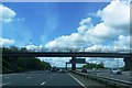
8
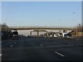
M6 motorway - Woolston Moss accommodation bridge
Image: © Peter Whatley
Taken: 17 Jan 2012
0.10 miles
10
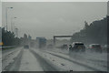
Woolston : M6 Motorway
The M6 between Junction 21A (Croft Interchange) and Junction 21.
Image: © Lewis Clarke
Taken: 27 Sep 2019
0.10 miles