IMAGES TAKEN NEAR TO
Moss Lane, WARRINGTON, WA3 5PP
Introduction
This page details the photographs taken nearby to Moss Lane, WA3 5PP by members of the Geograph project.
The Geograph project started in 2005 with the aim of publishing, organising and preserving representative images for every square kilometre of Great Britain, Ireland and the Isle of Man.

There are currently over 7.5m images from over14,400 individuals and you can help contribute to the project by visiting https://www.geograph.org.uk
Image Map
Images are licensed for reuse under creativecommons.org/licenses/by-sa/2.0
Notes
- Clicking on the map will re-center to the selected point.
- The higher the marker number, the further away the image location is from the centre of the postcode.
Image Listing (6 Images Found)
Images are licensed for reuse under creativecommons.org/licenses/by-sa/2.0
Image
Details
Distance
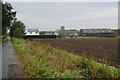
3
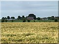
Across the Moss
Looking in a southeasterly direction at Moss Lodge Farm, Glazebury, on the edge of Chat Moss. SJ68709585
Image: © Keith Williamson
Taken: 26 Sep 2005
0.13 miles
4
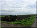
Tractors at Moss Lodge Farm
The tractors all appeared to be operational, rather than the discarded ones which are a feature of so many farms.
Image: © Bill Boaden
Taken: 2 Oct 2011
0.15 miles
5
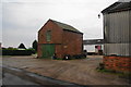
White Gate Farm
This farm appears to sell some produce on site.
Image: © Bill Boaden
Taken: 2 Oct 2011
0.23 miles
6
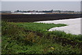
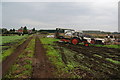
Vegetable production at Moss Lodge Farm
The soil is naturally rich and peaty.
Image: © Bill Boaden
Taken: 2 Oct 2011
0.24 miles