IMAGES TAKEN NEAR TO
Warrington Road, Leigh End, WARRINGTON, WA3 5NX
Introduction
This page details the photographs taken nearby to Warrington Road, Leigh End, WA3 5NX by members of the Geograph project.
The Geograph project started in 2005 with the aim of publishing, organising and preserving representative images for every square kilometre of Great Britain, Ireland and the Isle of Man.

There are currently over 7.5m images from over14,400 individuals and you can help contribute to the project by visiting https://www.geograph.org.uk
Image Map
Images are licensed for reuse under creativecommons.org/licenses/by-sa/2.0
Notes
- Clicking on the map will re-center to the selected point.
- The higher the marker number, the further away the image location is from the centre of the postcode.
Image Listing (27 Images Found)
Images are licensed for reuse under creativecommons.org/licenses/by-sa/2.0
Image
Details
Distance
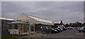
3
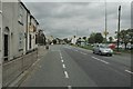
Warrington Road, Glazebury
This is a view looking north along Warrington Road (A574) as it passes through Glazebury. Taken from SJ 67102 97794
Image: © andy
Taken: 7 Sep 2005
0.07 miles
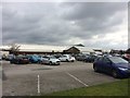
4
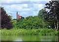
Across the Lake at Bent's Garden Centre
A Mill in Leigh can be seen in the distance.
Image: © Anthony Parkes
Taken: 15 Jul 2012
0.07 miles
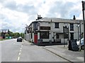
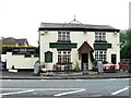
7
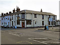
Comfortable Gill, Glazebury
The Comfortable Gill public house on Warrington Road, Glazebury.
Image: © David Dixon
Taken: 24 Mar 2011
0.07 miles
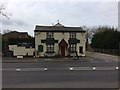
8

Foresters Arms
The Foresters Arms public house on Warrington Road, at Lately Common.
Image: © David Dixon
Taken: 24 Mar 2011
0.08 miles