IMAGES TAKEN NEAR TO
Light Oaks Road, WARRINGTON, WA3 5LH
Introduction
This page details the photographs taken nearby to Light Oaks Road, WA3 5LH by members of the Geograph project.
The Geograph project started in 2005 with the aim of publishing, organising and preserving representative images for every square kilometre of Great Britain, Ireland and the Isle of Man.

There are currently over 7.5m images from over14,400 individuals and you can help contribute to the project by visiting https://www.geograph.org.uk
Image Map
Images are licensed for reuse under creativecommons.org/licenses/by-sa/2.0
Notes
- Clicking on the map will re-center to the selected point.
- The higher the marker number, the further away the image location is from the centre of the postcode.
Image Listing (27 Images Found)
Images are licensed for reuse under creativecommons.org/licenses/by-sa/2.0
Image
Details
Distance
1
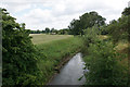
Glaze Brook near Glazebury
Looking downstream from Light Oaks Road.
Image: © Bill Boaden
Taken: 5 Jun 2020
0.02 miles
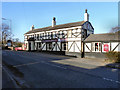
3
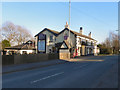
George & Dragon
The George and Dragon pub/restaurant on Warrington Road (A574), Glazebury
Image: © David Dixon
Taken: 18 Mar 2011
0.07 miles
4
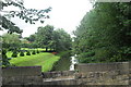
Glaze Brook from Light Oaks Hall Bridge
Image: © Anthony Parkes
Taken: 31 Jul 2010
0.07 miles
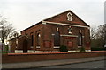
5
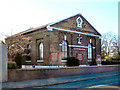
Glazebury Methodist Church
The methodist church on Warrington Road, at Glazebury.
Image: © David Dixon
Taken: 18 Mar 2011
0.07 miles
6

Glazebury Methodist Church
Glazebury Methodist Church on Warrington Road.
Image: © David Dixon
Taken: 18 Mar 2011
0.07 miles
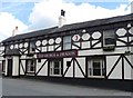
10
The George & Dragon, Glazebury
The George and Dragon pub/restaurant on Warrington Road, Glazebury.
Image: © David Dixon
Taken: 18 Mar 2011
0.08 miles