IMAGES TAKEN NEAR TO
Lansdowne, WARRINGTON, WA3 4EA
Introduction
This page details the photographs taken nearby to Lansdowne, WA3 4EA by members of the Geograph project.
The Geograph project started in 2005 with the aim of publishing, organising and preserving representative images for every square kilometre of Great Britain, Ireland and the Isle of Man.

There are currently over 7.5m images from over14,400 individuals and you can help contribute to the project by visiting https://www.geograph.org.uk
Image Map
Images are licensed for reuse under creativecommons.org/licenses/by-sa/2.0
Notes
- Clicking on the map will re-center to the selected point.
- The higher the marker number, the further away the image location is from the centre of the postcode.
Image Listing (29 Images Found)
Images are licensed for reuse under creativecommons.org/licenses/by-sa/2.0
Image
Details
Distance
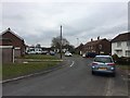
2
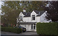
A house on the road from Risley to Culcheth
Image: © Ian Greig
Taken: 4 Oct 2011
0.07 miles
3
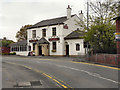
Thai Paragon
The Thai Paragon restaurant and bar on Warrington Road in Culcheth.
Image: © David Dixon
Taken: 18 Apr 2011
0.08 miles
5
The entrance to Newchurch Community Primary School
Image: © Ian Greig
Taken: 4 Oct 2011
0.09 miles
6
Road Junction, Culcheth
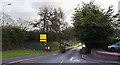
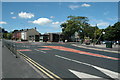
This is the junction (mini roundabout) of Warrington Road (A574) and Common Lane (B5207) at the centre of Culcheth, near Warrington. This is a view looking almost directly west.
Image: © andy
Taken: 8 Aug 2005
0.10 miles
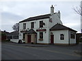
7
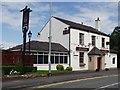
The Thai Paragon
Bar restaurant close to the centre of Culcheth.
Image: © philandju
Taken: 5 Jul 2012
0.10 miles
9
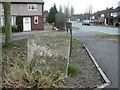
Culcheth, milestone
Slightly sunken milestone on A574. Legend reads "NEWCHURCH/TOWNSHIP OF/CULCHETH//TO/WARRINGTON/6/(MILES)//TO/LEIGH/4 3/4/(MILES)". As seen looking down Newchurch Lane. Erected by Lancashire County Council, late C19 or early C20.
Image: © Mike Faherty
Taken: 23 Jan 2009
0.14 miles
10
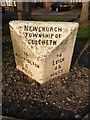
Old Milestone by the A574, Warrington Road, Culcheth
Carved stone post by the A574, in parish of Croft (Warrington District), Warrington Road, Culcheth, junction with Newchurch Lane, just North of railway bridge, on grass, on East side of road. Lancs. CC stone triangle, erected by the County Council in the 19th/20th century.
Inscription reads:-
: TO / WARRINGTON / 6 / MILES : : NEWCHURCH / TOWNSHIP OF / CULCHETH : : TO / LEIGH / 4¾ / MILES :
Grade II listed.
List Entry Number: 1392439 https://historicengland.org.uk/listing/the-list/list-entry/1392439
Milestone Society National ID: LA_WALH06
Image: © M Faherty
Taken: 23 Jan 2009
0.14 miles