IMAGES TAKEN NEAR TO
Glebeland, WARRINGTON, WA3 4DY
Introduction
This page details the photographs taken nearby to Glebeland, WA3 4DY by members of the Geograph project.
The Geograph project started in 2005 with the aim of publishing, organising and preserving representative images for every square kilometre of Great Britain, Ireland and the Isle of Man.

There are currently over 7.5m images from over14,400 individuals and you can help contribute to the project by visiting https://www.geograph.org.uk
Image Map
Images are licensed for reuse under creativecommons.org/licenses/by-sa/2.0
Notes
- Clicking on the map will re-center to the selected point.
- The higher the marker number, the further away the image location is from the centre of the postcode.
Image Listing (28 Images Found)
Images are licensed for reuse under creativecommons.org/licenses/by-sa/2.0
Image
Details
Distance
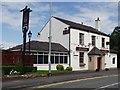
3
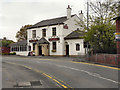
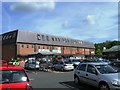
Thai Paragon
The Thai Paragon restaurant and bar on Warrington Road in Culcheth.
Image: © David Dixon
Taken: 18 Apr 2011
0.15 miles
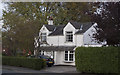
5
The entrance to Newchurch Community Primary School
Image: © Ian Greig
Taken: 4 Oct 2011
0.16 miles
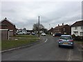
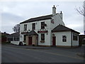
6
A house on the road from Risley to Culcheth
Image: © Ian Greig
Taken: 4 Oct 2011
0.16 miles
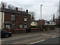
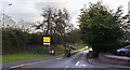
7
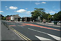
Road Junction, Culcheth
This is the junction (mini roundabout) of Warrington Road (A574) and Common Lane (B5207) at the centre of Culcheth, near Warrington. This is a view looking almost directly west.
Image: © andy
Taken: 8 Aug 2005
0.17 miles
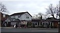
8
The Thai Paragon
Bar restaurant close to the centre of Culcheth.
Image: © philandju
Taken: 5 Jul 2012
0.18 miles