IMAGES TAKEN NEAR TO
Kenyon Lane, WARRINGTON, WA3 4AY
Introduction
This page details the photographs taken nearby to Kenyon Lane, WA3 4AY by members of the Geograph project.
The Geograph project started in 2005 with the aim of publishing, organising and preserving representative images for every square kilometre of Great Britain, Ireland and the Isle of Man.

There are currently over 7.5m images from over14,400 individuals and you can help contribute to the project by visiting https://www.geograph.org.uk
Image Map
Images are licensed for reuse under creativecommons.org/licenses/by-sa/2.0
Notes
- Clicking on the map will re-center to the selected point.
- The higher the marker number, the further away the image location is from the centre of the postcode.
Image Listing (8 Images Found)
Images are licensed for reuse under creativecommons.org/licenses/by-sa/2.0
Image
Details
Distance

4
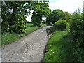
Main Lane, Kenyon
This back lane retains its original surface of two lines of stone setts (square stones) with a centre surface of cobbles; there is a road edge composed of slightly larger setts. The surface is still quite solid, though there are some drainage problems. It is still used by horse-riders, but has now been closed to traffic An interesting and unexpected bit of heritage.
Image: © John Boothby
Taken: 13 May 2012
0.16 miles

8
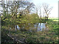
Field pond at Kenyon
Field pond in advanced vegetational succession. Of the c. 25,000 ponds in NW England, this is in a fairly typical state, with several trees overshadowing it, and showing considerable colonisation by bankside vegetation. The pond probably formed following marl extraction.
Image: © John Boothby
Taken: 19 Apr 2012
0.21 miles