IMAGES TAKEN NEAR TO
East Lancashire Road, WARRINGTON, WA3 4AR
Introduction
This page details the photographs taken nearby to East Lancashire Road, WA3 4AR by members of the Geograph project.
The Geograph project started in 2005 with the aim of publishing, organising and preserving representative images for every square kilometre of Great Britain, Ireland and the Isle of Man.

There are currently over 7.5m images from over14,400 individuals and you can help contribute to the project by visiting https://www.geograph.org.uk
Image Map
Images are licensed for reuse under creativecommons.org/licenses/by-sa/2.0
Notes
- Clicking on the map will re-center to the selected point.
- The higher the marker number, the further away the image location is from the centre of the postcode.
Image Listing (9 Images Found)
Images are licensed for reuse under creativecommons.org/licenses/by-sa/2.0
Image
Details
Distance
1
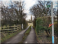
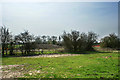
Footpath off the East Lancs Road
Footpath towards Glazebury, south of the A580 (East Lancashire Road).
Image: © David Dixon
Taken: 18 Feb 2012
0.02 miles
5
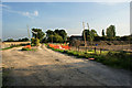
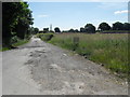
A construction access for the West East Link Pipeline
Image: © Ian Greig
Taken: 1 Sep 2010
0.11 miles
6
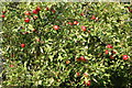
Fresh English apples ripe for the plucking at the roadside
Help yourself!
Image: © Ian Greig
Taken: 1 Sep 2010
0.13 miles
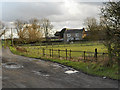
9
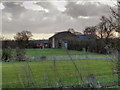
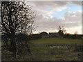
Wood's Farm
A farm to the south of the A580 (East Lancashire Road).
Image: © David Dixon
Taken: 18 Feb 2012
0.25 miles