IMAGES TAKEN NEAR TO
North Meadow Close, WARRINGTON, WA3 3YS
Introduction
This page details the photographs taken nearby to North Meadow Close, WA3 3YS by members of the Geograph project.
The Geograph project started in 2005 with the aim of publishing, organising and preserving representative images for every square kilometre of Great Britain, Ireland and the Isle of Man.

There are currently over 7.5m images from over14,400 individuals and you can help contribute to the project by visiting https://www.geograph.org.uk
Image Map
Images are licensed for reuse under creativecommons.org/licenses/by-sa/2.0
Notes
- Clicking on the map will re-center to the selected point.
- The higher the marker number, the further away the image location is from the centre of the postcode.
Image Listing (5 Images Found)
Images are licensed for reuse under creativecommons.org/licenses/by-sa/2.0
Image
Details
Distance
1
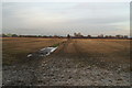
Footpath from Lowton Road, Golborne, to former railway embankment
Image: © David Long
Taken: 7 Dec 2008
0.11 miles
2

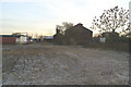
Dr Beeching, I presume!
Dismantled railway bridge on disused line to the northeast of Golborne. SJ61339878
Image: © Keith Williamson
Taken: 12 Sep 2005
0.14 miles
4
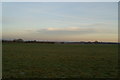
Fields of Wigan Road Farm, Abram
The sharp-eyed may pick out mill buildings in Leigh in the far distance.
Image: © David Long
Taken: 7 Dec 2008
0.24 miles
5

High and dry
A narrow boat in a haulage company's yard beside the A573 in Golborne.
Image: © David Long
Taken: 7 Dec 2008
0.24 miles