IMAGES TAKEN NEAR TO
Ashton Road, WARRINGTON, WA3 3UX
Introduction
This page details the photographs taken nearby to Ashton Road, WA3 3UX by members of the Geograph project.
The Geograph project started in 2005 with the aim of publishing, organising and preserving representative images for every square kilometre of Great Britain, Ireland and the Isle of Man.

There are currently over 7.5m images from over14,400 individuals and you can help contribute to the project by visiting https://www.geograph.org.uk
Image Map
Images are licensed for reuse under creativecommons.org/licenses/by-sa/2.0
Notes
- Clicking on the map will re-center to the selected point.
- The higher the marker number, the further away the image location is from the centre of the postcode.
Image Listing (12 Images Found)
Images are licensed for reuse under creativecommons.org/licenses/by-sa/2.0
Image
Details
Distance

5

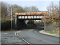
Ashton Road Railway Bridge
Bridge over the remains of the Ex Great Central branch line to St. Helens. This line now links into factory premises from the West Coast main line.
Image: © Raymond Knapman
Taken: 31 Mar 2008
0.20 miles
6
Dismantled railway bridge over Edge Green Lane
Image: © JThomas
Taken: 16 Feb 2013
0.21 miles
7
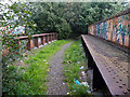
Dismantled Railway over Edge Green Lane
Image: © Gary Rogers
Taken: 19 Sep 2018
0.21 miles