IMAGES TAKEN NEAR TO
Dove Street, WARRINGTON, WA3 3UW
Introduction
This page details the photographs taken nearby to Dove Street, WA3 3UW by members of the Geograph project.
The Geograph project started in 2005 with the aim of publishing, organising and preserving representative images for every square kilometre of Great Britain, Ireland and the Isle of Man.

There are currently over 7.5m images from over14,400 individuals and you can help contribute to the project by visiting https://www.geograph.org.uk
Image Map
Images are licensed for reuse under creativecommons.org/licenses/by-sa/2.0
Notes
- Clicking on the map will re-center to the selected point.
- The higher the marker number, the further away the image location is from the centre of the postcode.
Image Listing (13 Images Found)
Images are licensed for reuse under creativecommons.org/licenses/by-sa/2.0
Image
Details
Distance
1
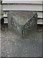
Old Milestone by the A573, Wigan Road, Wigan Parish
Carved stone post by the A573, in parish of WIGAN (WIGAN District), Golborne; opposite No. 15a, by the road, on West side of road. Lancashire CC stone triangle, erected by the County Council in the 19th/20th century.
Inscription reads:-
: WIGAN / 5 / MILES : : GOLBORNE : : WARRINGTON / 7 MILES :
Milestone Society National ID: LA_WGWA05.
Image: © J Higgins
Taken: 1 Sep 2008
0.13 miles
2
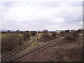
Edge Green Railway Siding
View from Golbourne Road Bridge showing the railway from the West Coast Main Line to the right,and the curving line towards the Edge Green Factory. The junction is directly under the bridge.
Image: © Raymond Knapman
Taken: 31 Mar 2008
0.15 miles
3

High and dry
A narrow boat in a haulage company's yard beside the A573 in Golborne.
Image: © David Long
Taken: 7 Dec 2008
0.20 miles
6

Ashton Road Railway Bridge
Bridge over the remains of the Ex Great Central branch line to St. Helens. This line now links into factory premises from the West Coast main line.
Image: © Raymond Knapman
Taken: 31 Mar 2008
0.21 miles
7
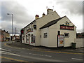
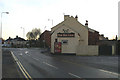
The Red Lion, Golborne
The Red Lion public house on Church Street (A573), opposite the junction with Lowton Road (B5207).
Image: © David Dixon
Taken: 21 Feb 2012
0.22 miles

9

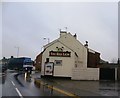
The Red Lion, Golborne, from Lowton Road
At the junction with Church Street (left) and Wigan Road (right), the A573.
Image: © David Long
Taken: 7 Dec 2008
0.23 miles
10
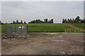
Open space at the end of Kid Glove Road
The capped mine indicates that it hasn't always been kid gloves here
Image: © Ian Greig
Taken: 8 Oct 2010
0.23 miles