IMAGES TAKEN NEAR TO
Rothwell Road, WARRINGTON, WA3 3EJ
Introduction
This page details the photographs taken nearby to Rothwell Road, WA3 3EJ by members of the Geograph project.
The Geograph project started in 2005 with the aim of publishing, organising and preserving representative images for every square kilometre of Great Britain, Ireland and the Isle of Man.

There are currently over 7.5m images from over14,400 individuals and you can help contribute to the project by visiting https://www.geograph.org.uk
Image Map
Images are licensed for reuse under creativecommons.org/licenses/by-sa/2.0
Notes
- Clicking on the map will re-center to the selected point.
- The higher the marker number, the further away the image location is from the centre of the postcode.
Image Listing (16 Images Found)
Images are licensed for reuse under creativecommons.org/licenses/by-sa/2.0
Image
Details
Distance
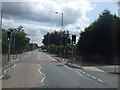
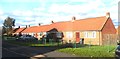
2
Pedestrian crossing at the junction of Heywood Avenue/ Derby Street/ Lowton Road
Image: © David Long
Taken: 3 Aug 2009
0.14 miles
4

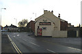
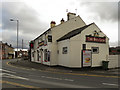
The Red Lion, Golborne, from Lowton Road
At the junction with Church Street (left) and Wigan Road (right), the A573.
Image: © David Long
Taken: 7 Dec 2008
0.19 miles

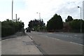
6
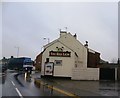
The Red Lion, Golborne
The Red Lion public house on Church Street (A573), opposite the junction with Lowton Road (B5207).
Image: © David Dixon
Taken: 21 Feb 2012
0.21 miles
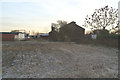
9

High and dry
A narrow boat in a haulage company's yard beside the A573 in Golborne.
Image: © David Long
Taken: 7 Dec 2008
0.21 miles