IMAGES TAKEN NEAR TO
Parkside Road, WARRINGTON, WA3 1PG
Introduction
This page details the photographs taken nearby to Parkside Road, WA3 1PG by members of the Geograph project.
The Geograph project started in 2005 with the aim of publishing, organising and preserving representative images for every square kilometre of Great Britain, Ireland and the Isle of Man.

There are currently over 7.5m images from over14,400 individuals and you can help contribute to the project by visiting https://www.geograph.org.uk
Image Map
Images are licensed for reuse under creativecommons.org/licenses/by-sa/2.0
Notes
- Clicking on the map will re-center to the selected point.
- The higher the marker number, the further away the image location is from the centre of the postcode.
Image Listing (34 Images Found)
Images are licensed for reuse under creativecommons.org/licenses/by-sa/2.0
Image
Details
Distance
1
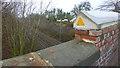
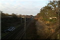
Parkside (A573) Road Railway Bridge
Parapets raised and steeple copings recently added in advance of overhead electrification.
Image: © Richard Cooke
Taken: 13 Jan 2013
0.03 miles
2

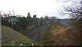
West Coast Main Line spur to Liverpool
The junction with the Liverpool-Manchester line, hidden by the bend, is just before the M6 bridge.
Image: © David Long
Taken: 2 Jan 2009
0.04 miles
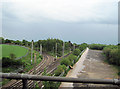
4
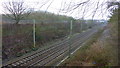
Liverpool to Manchester Line
Looking towards Newton-Le-Willows
Engineer's Line Reference: DSE (Deal Street to Eccles)
Bridge carrying the M6 in the background
Image: © Richard Cooke
Taken: 13 Jan 2013
0.04 miles
5
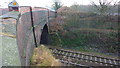
Parkside Road (A573) Railway Bridge
Parapets raised to 1.5m and steeple copings recently added in advance of overhead electrification.
Image: © Richard Cooke
Taken: 13 Jan 2013
0.04 miles
6
Liverpool-Manchester line, Liverpool Junction, Parkside
The rear of the train is passing over the junction points. Note the overhead cables for the main line trains. They end here.
Image: © David Long
Taken: 2 Jan 2009
0.07 miles
7
Railway Junction at Lowton
From M6 southbound
Image: © John Firth
Taken: 13 May 2011
0.07 miles
8
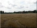
Town of Lowton, cornfield
Cornfield looking ready for harvesting; to the left, railway electricity gantries, to the right, lorries on M6.
Image: © Mike Faherty
Taken: 1 Sep 2009
0.09 miles
9
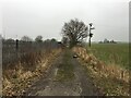
Farm track alongside the railway near Highfield Farm
Image: © Steven Brown
Taken: 24 Jan 2022
0.09 miles
10

Royal Train hideaway
The map shows a series of junctions hereabouts. From beneath the bridge a connection comes off the West Coast Main Line to this junction, known as Lowton Junction. To the right the line meets the Liverpool-Manchester Railway's line at Newton-le-Willows junction (marked as "Parkside Liverpool Junction" on the OS maps). To the left the same line is met at Parkside Junction ("Parkside Manchester Junction" on the maps). This forms a triangle from which a train may move easily in four directions. It is also a quiet spot, remote from townships. An ideal resting place for the Royal Train when it is in the region.
Image: © David Long
Taken: 2 Jan 2009
0.11 miles