IMAGES TAKEN NEAR TO
Heath Lane, WARRINGTON, WA3 1HR
Introduction
This page details the photographs taken nearby to Heath Lane, WA3 1HR by members of the Geograph project.
The Geograph project started in 2005 with the aim of publishing, organising and preserving representative images for every square kilometre of Great Britain, Ireland and the Isle of Man.

There are currently over 7.5m images from over14,400 individuals and you can help contribute to the project by visiting https://www.geograph.org.uk
Image Map
Images are licensed for reuse under creativecommons.org/licenses/by-sa/2.0
Notes
- Clicking on the map will re-center to the selected point.
- The higher the marker number, the further away the image location is from the centre of the postcode.
Image Listing (4 Images Found)
Images are licensed for reuse under creativecommons.org/licenses/by-sa/2.0
Image
Details
Distance
1
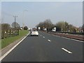
A580 at the former Heath Lane crossroads
The crossroads here has been fenced off (as left) in favour of the Stone Cross Lane junctions slightly further west.
Image: © Peter Whatley
Taken: 24 Mar 2011
0.07 miles
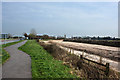
3

The line of the West East Link Pipeline veers away from the East Lancashire Road
(and the houses at Lowton)
Image: © Ian Greig
Taken: 7 Jul 2010
0.14 miles
4
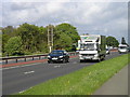
Mid-afternoon traffic on A580, Lowton
Opened in 1934, the A580 (East Lancs Rd) carried about 31,000 vehicles per day in 2010 [Official Count Data ]. A major source of ambient noise, it was originally intended to reach the east of Lancashire, but never made it, and was "replaced" by the motorway network.
Image: © John Boothby
Taken: 11 May 2012
0.16 miles