IMAGES TAKEN NEAR TO
Canaan, WARRINGTON, WA3 1EG
Introduction
This page details the photographs taken nearby to Canaan, WA3 1EG by members of the Geograph project.
The Geograph project started in 2005 with the aim of publishing, organising and preserving representative images for every square kilometre of Great Britain, Ireland and the Isle of Man.

There are currently over 7.5m images from over14,400 individuals and you can help contribute to the project by visiting https://www.geograph.org.uk
Image Map
Images are licensed for reuse under creativecommons.org/licenses/by-sa/2.0
Notes
- Clicking on the map will re-center to the selected point.
- The higher the marker number, the further away the image location is from the centre of the postcode.
Image Listing (7 Images Found)
Images are licensed for reuse under creativecommons.org/licenses/by-sa/2.0
Image
Details
Distance
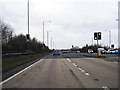
1

The A579, Atherleigh Way, turning off the East Lancs Road
Image: © David Long
Taken: 3 Jan 2009
0.20 miles

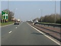
5
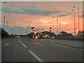
East Lancashire Road (A580), Pocket Nook
The westbound A580, approaching its junction with the A579.
Image: © David Dixon
Taken: 17 Sep 2010
0.23 miles
6
A580 approaching Pocket Nook junction (A579)
The road rises to the junction as the site was formerly a bridge over the railway whose trackbed is now used by the A579. The railway - the Tyldesley Loop - was one of the last lost under the Labour governments' decimation of Britain's passenger railways in the 1960s.
Image: © Peter Whatley
Taken: 24 Mar 2011
0.23 miles