IMAGES TAKEN NEAR TO
Slag Lane, WARRINGTON, WA3 1BU
Introduction
This page details the photographs taken nearby to Slag Lane, WA3 1BU by members of the Geograph project.
The Geograph project started in 2005 with the aim of publishing, organising and preserving representative images for every square kilometre of Great Britain, Ireland and the Isle of Man.

There are currently over 7.5m images from over14,400 individuals and you can help contribute to the project by visiting https://www.geograph.org.uk
Image Map
Images are licensed for reuse under creativecommons.org/licenses/by-sa/2.0
Notes
- Clicking on the map will re-center to the selected point.
- The higher the marker number, the further away the image location is from the centre of the postcode.
Image Listing (17 Images Found)
Images are licensed for reuse under creativecommons.org/licenses/by-sa/2.0
Image
Details
Distance

4
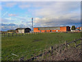
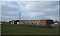
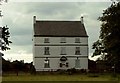
Little Byrom Hall Farm
Farm off Slag Lane.
Image: © David Dixon
Taken: 21 Feb 2012
0.10 miles
7
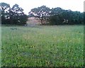
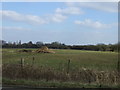
Wild flower meadow
Rough land, re-planted by, I think, English Nature and converted to wild flower meadows. About 400yds off Slag Lane, by the junction with Byrom Lane.
Image: © Pam Nash
Taken: Unknown
0.19 miles
9
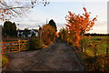
Byrom Hall, Slag Lane Lowton
Information on the history of Byrom Hall can he found on the website www.lowtonhistory.co.nr
Image: © Alan Nixon
Taken: 17 Jul 2006
0.22 miles
