IMAGES TAKEN NEAR TO
Byrom Lane, WARRINGTON, WA3 1BL
Introduction
This page details the photographs taken nearby to Byrom Lane, WA3 1BL by members of the Geograph project.
The Geograph project started in 2005 with the aim of publishing, organising and preserving representative images for every square kilometre of Great Britain, Ireland and the Isle of Man.

There are currently over 7.5m images from over14,400 individuals and you can help contribute to the project by visiting https://www.geograph.org.uk
Image Map
Images are licensed for reuse under creativecommons.org/licenses/by-sa/2.0
Notes
- Clicking on the map will re-center to the selected point.
- The higher the marker number, the further away the image location is from the centre of the postcode.
Image Listing (18 Images Found)
Images are licensed for reuse under creativecommons.org/licenses/by-sa/2.0
Image
Details
Distance
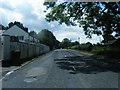
2
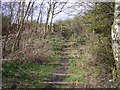
Footpath on Trackbed of ex Great Central Railway
The steps lead from the pathway along the trackbed of the Wigan branch of the ex Great Central Railway up to Byrom Lane.
Image: © Raymond Knapman
Taken: 31 Mar 2008
0.10 miles
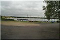
3
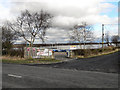
Leigh and Lowton Sailing Club, Green Lane
The entrance to the Leigh and Lowton Sailing Club on Green Lane
Image: © David Dixon
Taken: 21 Feb 2012
0.11 miles
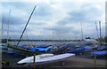
5
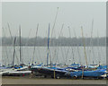
Dinghies at Leigh and Lowton Sailing Club
Green Lane, Leigh
Image: © Gary Rogers
Taken: 12 Mar 2015
0.15 miles


10
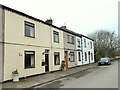
Wilton Cottages, Green Lane
On the banks of Pennington Flash, Leigh
Image: © Gary Rogers
Taken: 12 Mar 2015
0.19 miles