IMAGES TAKEN NEAR TO
Green House Close, WARRINGTON, WA3 1AD

Introduction

This page details the photographs taken nearby to Green House Close, WA3 1AD by members of the Geograph project.

The Geograph project started in 2005 with the aim of publishing, organising and preserving representative images for every square kilometre of Great Britain, Ireland and the Isle of Man.

There are currently over 7.5m images from over14,400 individuals and you can help contribute to the project by visiting https://www.geograph.org.uk

Image Map


Images are licensed for reuse under creativecommons.org/licenses/by-sa/2.0
Notes
  • Clicking on the map will re-center to the selected point.
  • The higher the marker number, the further away the image location is from the centre of the postcode.

Image Listing (27 Images Found)

Images are licensed for reuse under creativecommons.org/licenses/by-sa/2.0
  • ...
Image
Details
Distance
1
New housing off Sandy Lane
Image: © JThomas Taken: 2 Mar 2013
0.02 miles
2
Sandy Lane, Lowton Common
Image: © JThomas Taken: 2 Mar 2013
0.03 miles
3
Lowton Independent Methodist Church
Image: © JOHN NIXON Taken: Unknown
0.10 miles
4
Lowton Independent Methodist Church
The Methodist church on Newton Road at Lowton Saint Mary's, was founded in 1819.
Image: © David Dixon Taken: 21 Feb 2012
0.12 miles
5
The footpath by Liptrot Farm
Image: © Ian Greig Taken: 31 Oct 2010
0.13 miles
6
Independent Methodist Church, Lowton Common
Image: © JThomas Taken: 2 Mar 2013
0.13 miles
7
Newton Road, Lowton Common
St Mary's Church is just off the photo centre Left and the front wall of the Independent Methodist Church can be seen centre Right
Image: © Alan Nixon Taken: 17 Jul 2006
0.14 miles
8
The Church Inn
The Church Inn is at the junction of Sandy Lane and Newton Road, opposite Image], although the church depicted on the inn sign (Image]) bears no resemblance at all to St Mary's.
Image: © David Dixon Taken: 21 Feb 2012
0.14 miles
9
Church Inn Sign
The sign for Image], at Lowton, bears no resemblance at all to the church across the road (Image]).
Image: © David Dixon Taken: 21 Feb 2012
0.15 miles
10
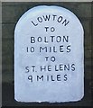
Old Milestone by the A572, Newton Road, Golborne parish
Carved stone post by the A572, in parish of GOLBORNE (WIGAN District), Newton Road; Wash End, against churchyard wall of parish church, on South side of road. St Helens stone, erected by the Bolton & St Helens turnpike trust in the 19th century. Inscription reads:- TO BOLTON 10 MILES TO ST. HELENS 9 MILES Milestone Society National ID: LA_BOSH10
Image: © M Faherty Taken: 1 Sep 2009
0.15 miles
  • ...