IMAGES TAKEN NEAR TO
Ajax Avenue, WARRINGTON, WA2 9RN
Introduction
This page details the photographs taken nearby to Ajax Avenue, WA2 9RN by members of the Geograph project.
The Geograph project started in 2005 with the aim of publishing, organising and preserving representative images for every square kilometre of Great Britain, Ireland and the Isle of Man.

There are currently over 7.5m images from over14,400 individuals and you can help contribute to the project by visiting https://www.geograph.org.uk
Image Map
Images are licensed for reuse under creativecommons.org/licenses/by-sa/2.0
Notes
- Clicking on the map will re-center to the selected point.
- The higher the marker number, the further away the image location is from the centre of the postcode.
Image Listing (4 Images Found)
Images are licensed for reuse under creativecommons.org/licenses/by-sa/2.0
Image
Details
Distance
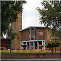
3
L.A. Bowl, Warrington
This is one of the many industrial units that make up Winwick Quay and this particular one is known as Chetham Court and is quite popular with the general public because it also houses L.A. Bowl which is a ten pin bowling complex. L.A. Bowl is unfortunately obscured slightly by trees but is the red section towards the middle of the unit.
Image: © andy
Taken: 13 Jul 2005
0.23 miles