IMAGES TAKEN NEAR TO
Beckett Drive, WARRINGTON, WA2 8XJ
Introduction
This page details the photographs taken nearby to Beckett Drive, WA2 8XJ by members of the Geograph project.
The Geograph project started in 2005 with the aim of publishing, organising and preserving representative images for every square kilometre of Great Britain, Ireland and the Isle of Man.

There are currently over 7.5m images from over14,400 individuals and you can help contribute to the project by visiting https://www.geograph.org.uk
Image Map
Images are licensed for reuse under creativecommons.org/licenses/by-sa/2.0
Notes
- Clicking on the map will re-center to the selected point.
- The higher the marker number, the further away the image location is from the centre of the postcode.
Image Listing (20 Images Found)
Images are licensed for reuse under creativecommons.org/licenses/by-sa/2.0
Image
Details
Distance
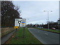
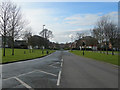
1
Winwick
Roundabout at centre of Winwick Park housing estate
Image: © Richard Cooke
Taken: 19 Aug 2012
0.08 miles
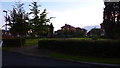
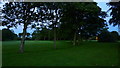
2
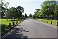
Tree lined avenue, Winwick
Looks like this road has not always been grassed over.
Image: © A Whitmore
Taken: 10 Jul 2008
0.09 miles
3
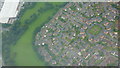
Winwick Park from the Air
Residential development built circa 2000 on the site of Winwick Hospital. Taken from an Easyjet flight from Tallinn inbound to Liverpool Airport runway 27 as it banks right heading for Warrington.
Image: © Richard Cooke
Taken: 13 Sep 2012
0.12 miles
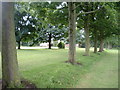
4
Winwick
Trees lining old road into Winwick Hospital, now a housing estate
Image: © Richard Cooke
Taken: 19 Aug 2012
0.13 miles
5
Winwick Park Avenue
The entrance road into the Winwick Park estate from the A49 at Winwick.
Image: © Mike Lyne
Taken: 13 Feb 2012
0.14 miles
7
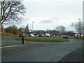
Small roundabout on Delph Lane
This small roundabout joins Delph Lane (which goes on ahead to join up with the A49 Winwick Road) and the access to McDonald's and B&Q's Retail Warehouse.
Image: © Mike Lyne
Taken: 13 Feb 2012
0.16 miles
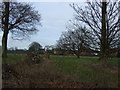
9
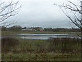
GreenLea House and grounds
Greenlea House in the distance behind a low-lying flooded field along the side of Mill Lane, near Winwick.
Image: © Mike Lyne
Taken: 13 Feb 2012
0.17 miles