IMAGES TAKEN NEAR TO
Newton Road, WARRINGTON, WA2 8SH
Introduction
This page details the photographs taken nearby to Newton Road, WA2 8SH by members of the Geograph project.
The Geograph project started in 2005 with the aim of publishing, organising and preserving representative images for every square kilometre of Great Britain, Ireland and the Isle of Man.

There are currently over 7.5m images from over14,400 individuals and you can help contribute to the project by visiting https://www.geograph.org.uk
Image Map
Images are licensed for reuse under creativecommons.org/licenses/by-sa/2.0
Notes
- Clicking on the map will re-center to the selected point.
- The higher the marker number, the further away the image location is from the centre of the postcode.
Image Listing (7 Images Found)
Images are licensed for reuse under creativecommons.org/licenses/by-sa/2.0
Image
Details
Distance
2
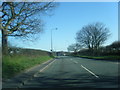
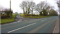
The A49 Winwick Road/Newton Road
As it is at the Winwick end it is more likely to be Newton Road here
Image: © Ian Greig
Taken: 12 Dec 2010
0.08 miles
3
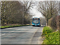
Newton Road (A49)
Arriva bus number 2800 (registration Y228 CJW), a Volvo B7L with Wright Eclipse coachwork, travelling towards Warrington on route number 360.
Image: © David Dixon
Taken: 24 Mar 2012
0.10 miles
4
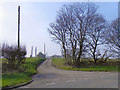
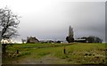
Cop Holt Farm
The track to Cop Holt Farm, from Newton Road (A49).
Image: © David Dixon
Taken: 24 Mar 2012
0.10 miles
6
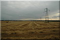
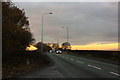
View across farmers field
This is a view across a farmers field looking south west from Newton Road (A49). As you can see... Mr Farmer was busy. And guess what you can see in the far distance... yep, Fiddlers Ferry Power Station... again.
Image: © andy
Taken: 27 Jul 2005
0.13 miles