IMAGES TAKEN NEAR TO
Myddleton Lane, WARRINGTON, WA2 8NA
Introduction
This page details the photographs taken nearby to Myddleton Lane, WA2 8NA by members of the Geograph project.
The Geograph project started in 2005 with the aim of publishing, organising and preserving representative images for every square kilometre of Great Britain, Ireland and the Isle of Man.

There are currently over 7.5m images from over14,400 individuals and you can help contribute to the project by visiting https://www.geograph.org.uk
Image Map
Images are licensed for reuse under creativecommons.org/licenses/by-sa/2.0
Notes
- Clicking on the map will re-center to the selected point.
- The higher the marker number, the further away the image location is from the centre of the postcode.
Image Listing (21 Images Found)
Images are licensed for reuse under creativecommons.org/licenses/by-sa/2.0
Image
Details
Distance
2
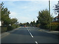
Myddleton Lane
The bridge taking Myddleton Lane over the Winwick Link Road (A49)
Image: © David Dixon
Taken: 24 Mar 2012
0.05 miles
4

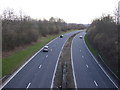
Winwick Link Road
A mile or so of dual carriageway linking the A49 as it passes though Winwick with junction 22 of the M6 it is a spur as it is also designated as the A49. This is looking south west as the road swings round past the village, from the bridge which carries Myddleton Lane over.
Image: © David Lally
Taken: 15 Apr 2010
0.05 miles
5

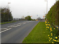
Very high keep left sign
A new traffic island is being constructed just over the brow of Myddleton Lane. This has required the adding of a very tall pole to warn drivers heading east. Else they would only see it when about 10 metres away.
The brow itself is only there as the lane has to rise to pass over the A49 dual carriageway.
Image: © David Lally
Taken: 15 Apr 2010
0.06 miles
6
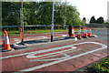
New traffic island
On Myddleton Lane on the eastern edge of Winwick. This is just to the east of the bridge over the A49 Winwick Link Road, which means that the pole in the centre of the picture is very high to warn motorists who cannot see it from over the bridge when heading out of the village. See Image
Image: © David Lally
Taken: 15 Apr 2010
0.07 miles
7

The Winwick Link Road (A49)
Looking south from the bridge at Myddleton Lane.
Image: © David Dixon
Taken: 24 Mar 2012
0.08 miles
8
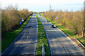
Winwick Link Road
A mile or so of dual carriageway linking the A49 as it passes though Winwick with junction 22 of the M6 it is a spur as it is also designated as the A49. This is looking north toward the motorway from the bridge which carries Myddleton Lane over.
Image: © David Lally
Taken: 15 Apr 2010
0.11 miles
9
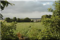
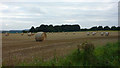
Arbury Farm, Winwick
This is a view over land which is part of Arbury Farm. Arbury Farm is mostly obscured by trees in the middle distance of this photograph and a barn can just be seen to the right of centre. Not sure what's in the field but I reckon it's some kind of root vegetable.
Image: © andy
Taken: 19 Jul 2005
0.13 miles