IMAGES TAKEN NEAR TO
Alder Lane, WARRINGTON, WA2 8HR
Introduction
This page details the photographs taken nearby to Alder Lane, WA2 8HR by members of the Geograph project.
The Geograph project started in 2005 with the aim of publishing, organising and preserving representative images for every square kilometre of Great Britain, Ireland and the Isle of Man.

There are currently over 7.5m images from over14,400 individuals and you can help contribute to the project by visiting https://www.geograph.org.uk
Image Map
Images are licensed for reuse under creativecommons.org/licenses/by-sa/2.0
Notes
- Clicking on the map will re-center to the selected point.
- The higher the marker number, the further away the image location is from the centre of the postcode.
Image Listing (11 Images Found)
Images are licensed for reuse under creativecommons.org/licenses/by-sa/2.0
Image
Details
Distance
1
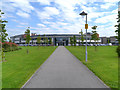
The Orford Jubilee Park
The Orford Jubilee Park was officially opened by HRH Queen Elizabeth II on 17th May 2012 and opened to the public on 18th May 2012. The Orford Park project is the largest Olympic legacy development outside London. The new ‘state of the art’ facilities within the £30million Orford Park Project will offer course provision for Warrington Collegiate's sports, leisure and health education.
The facilities will include dance studios, fitness lab, gym, sports hall, squash courts, swimming pools, steam room and sauna.
Image: © David Dixon
Taken: 24 Jul 2012
0.07 miles
2

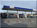
Petrol Station on Winwick Road
The Shell Petrol Station on Winwick Road
Image: © Mike Lyne
Taken: 3 Feb 2012
0.08 miles
4
Brook at Longford 2
Longford Brook running west from Orford Park and into Dallam Brook.
Image: © Sue Adair
Taken: 16 Mar 2012
0.13 miles
5
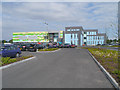
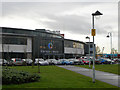
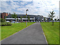
Warrington Collegiate
New college buildings at the junction of Winwick Road (A49) and Long lane (A50).
Image: © David Dixon
Taken: 24 Jul 2012
0.21 miles
6
Warrington Collegiate
Outside of the Warrington Collegiate from Long Lane
Image: © Mike Lyne
Taken: 26 Jan 2012
0.21 miles
7
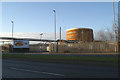
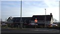
Gasometer beside the A49
The site of the first Warrington Provisional IRA bombing in February 1993. In March a second bombing took place in the town centre, killing younsters Johnathan Ball and Tim Parry.
Image: © David Long
Taken: 2 Jan 2009
0.21 miles
8
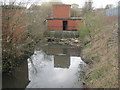
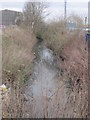
Brook at Longford
Longford Brook, just before it joins Dallam Brook; like many urban waterways it has just become a receptacle for rubbish and litter.
Image: © Sue Adair
Taken: 16 Mar 2012
0.21 miles
9
Warrington Collegiate
New college buildings at the junction of Winwick Road (A49) and Long lane (A50).
Image: © David Dixon
Taken: 24 Jul 2012
0.22 miles