IMAGES TAKEN NEAR TO
Arbury Lane, WARRINGTON, WA2 0RJ
Introduction
This page details the photographs taken nearby to Arbury Lane, WA2 0RJ by members of the Geograph project.
The Geograph project started in 2005 with the aim of publishing, organising and preserving representative images for every square kilometre of Great Britain, Ireland and the Isle of Man.

There are currently over 7.5m images from over14,400 individuals and you can help contribute to the project by visiting https://www.geograph.org.uk
Image Map
Images are licensed for reuse under creativecommons.org/licenses/by-sa/2.0
Notes
- Clicking on the map will re-center to the selected point.
- The higher the marker number, the further away the image location is from the centre of the postcode.
Image Listing (23 Images Found)
Images are licensed for reuse under creativecommons.org/licenses/by-sa/2.0
Image
Details
Distance
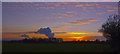
1
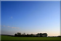
Trees surrounding Arbury
Airliner condensation trails are conspicuous by their absence on the first evening of UK airspace being cleared due to an ash cloud from a volcano beneath the Eyjafjallajoekul glacier in Iceland.
Flights did not resume for another six days. As I wrote this the first noisy Bu**er I have heard since this was taken has taken off from East Midlands Airport. I swore at it, but I don't think anyone heard (except my wife in the kitchen).
Image: © David Lally
Taken: 15 Apr 2010
0.02 miles
2
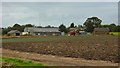
Arbury Lane Farm, Winwick
Taken from public footpath
Image: © Richard Cooke
Taken: 14 Sep 2012
0.03 miles
3
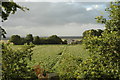
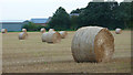
Arbury Farm, Winwick
This is a view over land which is part of Arbury Farm. Arbury Farm is mostly obscured by trees in the middle distance of this photograph and a barn can just be seen to the right of centre. Not sure what's in the field but I reckon it's some kind of root vegetable.
Image: © andy
Taken: 19 Jul 2005
0.04 miles
6
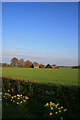
Arbury Cottages
With daffodils in front and a contrail-free sky behind.
Image: © David Lally
Taken: 15 Apr 2010
0.11 miles
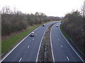
7

Winwick Link Road
A mile or so of dual carriageway linking the A49 as it passes though Winwick with junction 22 of the M6 it is a spur as it is also designated as the A49. This is looking south west as the road swings round past the village, from the bridge which carries Myddleton Lane over.
Image: © David Lally
Taken: 15 Apr 2010
0.11 miles
9
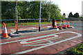
New traffic island
On Myddleton Lane on the eastern edge of Winwick. This is just to the east of the bridge over the A49 Winwick Link Road, which means that the pole in the centre of the picture is very high to warn motorists who cannot see it from over the bridge when heading out of the village. See Image
Image: © David Lally
Taken: 15 Apr 2010
0.12 miles
10
The plumes from Fiddler's Ferry Power Station
Image: © Ian Greig
Taken: 28 Jan 2012
0.12 miles