IMAGES TAKEN NEAR TO
Merry Farm Drive, KNUTSFORD, WA16 9TD
Introduction
This page details the photographs taken nearby to Merry Farm Drive, WA16 9TD by members of the Geograph project.
The Geograph project started in 2005 with the aim of publishing, organising and preserving representative images for every square kilometre of Great Britain, Ireland and the Isle of Man.

There are currently over 7.5m images from over14,400 individuals and you can help contribute to the project by visiting https://www.geograph.org.uk
Image Map
Images are licensed for reuse under creativecommons.org/licenses/by-sa/2.0
Notes
- Clicking on the map will re-center to the selected point.
- The higher the marker number, the further away the image location is from the centre of the postcode.
Image Listing (13 Images Found)
Images are licensed for reuse under creativecommons.org/licenses/by-sa/2.0
Image
Details
Distance
1
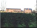
Oak Tree Barn & Merry Farm , Plumley Moor Road
Between Lower Peover & Plumley. Was known just as Merry Farm until the barn was converted.
Image: © Ian Warburton
Taken: 25 Nov 2005
0.10 miles
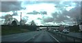
3

M6 Motorway
Looking north up the M6.
Image: © Peter McDermott
Taken: 13 Sep 2014
0.22 miles
4
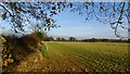
Last of the autumn colours in field boundary, NW of Smithy Green, Lower Peover
Image: © Colin Park
Taken: 7 Dec 2016
0.22 miles
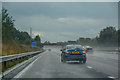
5

Cheshire East : The M6 Motorway
Heading northbound and past some roadworks on the M6 Motorway.
Image: © Lewis Clarke
Taken: 21 Apr 2016
0.22 miles
6
Pastureland NW of Smithy Green, Lower Peover
Image: © Colin Park
Taken: 7 Dec 2016
0.22 miles
7
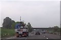
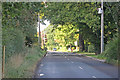
Plumley Road overbridge M6 south
The phone mast can be seen above the lorry
Image: © John Firth
Taken: 20 May 2014
0.23 miles
8
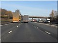
M6 Motorway - Plumley Moor Road overbridge
Image: © Peter Whatley
Taken: 21 Jan 2011
0.23 miles
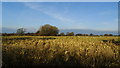
10
Plumley : M6 Motorway
The M6 between Junction 19 and Junction 18.
Image: © Lewis Clarke
Taken: 27 Sep 2019
0.24 miles