IMAGES TAKEN NEAR TO
Hulme Lane, KNUTSFORD, WA16 9SH
Introduction
This page details the photographs taken nearby to Hulme Lane, WA16 9SH by members of the Geograph project.
The Geograph project started in 2005 with the aim of publishing, organising and preserving representative images for every square kilometre of Great Britain, Ireland and the Isle of Man.

There are currently over 7.5m images from over14,400 individuals and you can help contribute to the project by visiting https://www.geograph.org.uk
Image Map
Images are licensed for reuse under creativecommons.org/licenses/by-sa/2.0
Notes
- Clicking on the map will re-center to the selected point.
- The higher the marker number, the further away the image location is from the centre of the postcode.
Image Listing (7 Images Found)
Images are licensed for reuse under creativecommons.org/licenses/by-sa/2.0
Image
Details
Distance
1
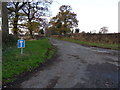
Tee Road
Dead end lane leading to Cape of Good Hope Farm, near Lach Dennis.
Image: © J Scott
Taken: 25 Nov 2010
0.11 miles
2
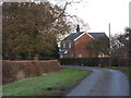
On The Curve
Country lane dwelling, near Lach Dennis.
Image: © J Scott
Taken: 25 Nov 2010
0.18 miles
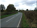
5
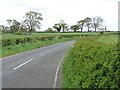
32 metre spot height, on Common Lane
On the north side of Portford Bridge.
Image: © Christine Johnstone
Taken: 13 May 2012
0.23 miles
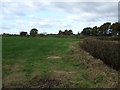
6
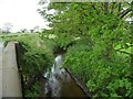
Crow Brook
Upstream [east] of Portford Bridge [Common Lane].
Image: © Christine Johnstone
Taken: 13 May 2012
0.23 miles
7
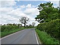
Portford Bridge
Where Common Lane crosses Crow Brook.
Image: © Christine Johnstone
Taken: 13 May 2012
0.25 miles