IMAGES TAKEN NEAR TO
Plumley Moor Road, KNUTSFORD, WA16 9SD
Introduction
This page details the photographs taken nearby to Plumley Moor Road, WA16 9SD by members of the Geograph project.
The Geograph project started in 2005 with the aim of publishing, organising and preserving representative images for every square kilometre of Great Britain, Ireland and the Isle of Man.

There are currently over 7.5m images from over14,400 individuals and you can help contribute to the project by visiting https://www.geograph.org.uk
Image Map
Images are licensed for reuse under creativecommons.org/licenses/by-sa/2.0
Notes
- Clicking on the map will re-center to the selected point.
- The higher the marker number, the further away the image location is from the centre of the postcode.
Image Listing (7 Images Found)
Images are licensed for reuse under creativecommons.org/licenses/by-sa/2.0
Image
Details
Distance
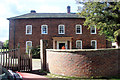
2
Oak Tree Barn & Merry Farm , Plumley Moor Road
Between Lower Peover & Plumley. Was known just as Merry Farm until the barn was converted.
Image: © Ian Warburton
Taken: 25 Nov 2005
0.10 miles
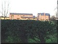
4
Pastureland NW of Smithy Green, Lower Peover
Image: © Colin Park
Taken: 7 Dec 2016
0.17 miles
5
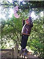
Scarecrow
The parachutist scarecrow just hanging about
Image: © Alan James
Taken: 5 Aug 2003
0.18 miles
6
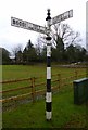
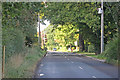
Old Direction Sign - Signpost by the B5081, Middlewich Road
Pawn finial - 2 arms; Cheshire New CCC octagonal by the B5081, in parish of Peover Inferior (Macclesfield District), junction of Middlewich Road with Plumley Moor Road, on verge, East side of road.
Surveyed
Milestone Society National ID: CH_SJ7474
Image: © Milestone Society
Taken: Unknown
0.23 miles
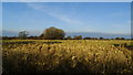
7
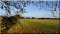
Last of the autumn colours in field boundary, NW of Smithy Green, Lower Peover
Image: © Colin Park
Taken: 7 Dec 2016
0.24 miles