IMAGES TAKEN NEAR TO
Pinfold Lane, KNUTSFORD, WA16 9RW
Introduction
This page details the photographs taken nearby to Pinfold Lane, WA16 9RW by members of the Geograph project.
The Geograph project started in 2005 with the aim of publishing, organising and preserving representative images for every square kilometre of Great Britain, Ireland and the Isle of Man.

There are currently over 7.5m images from over14,400 individuals and you can help contribute to the project by visiting https://www.geograph.org.uk
Image Map
Images are licensed for reuse under creativecommons.org/licenses/by-sa/2.0
Notes
- Clicking on the map will re-center to the selected point.
- The higher the marker number, the further away the image location is from the centre of the postcode.
Image Listing (16 Images Found)
Images are licensed for reuse under creativecommons.org/licenses/by-sa/2.0
Image
Details
Distance
1
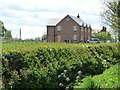
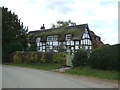
Large new house on Pinfold Lane
Near Laurel Cottage and Wood's Tenement.
Image: © Christine Johnstone
Taken: 13 May 2012
0.01 miles
2
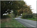
Pinfold Lane, near Wood's Tenement
A pinfold was an enclosure [fold] where stray animals were held until the owners paid the Pinder [official] a fine.
Image: © Christine Johnstone
Taken: 13 May 2012
0.06 miles
4
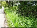
Wildflowers in the hedgerow
On the west side of Pinfold Lane, near Wood's Tenement.
Image: © Christine Johnstone
Taken: 13 May 2012
0.06 miles
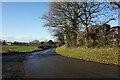
5
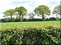
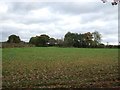
Trees along a field boundary
East of Pinfold Lane.
Image: © Christine Johnstone
Taken: 13 May 2012
0.07 miles
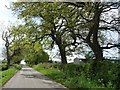
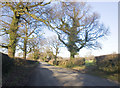
6
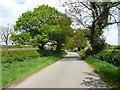
Pinfold Lane
No sign of a medieval enclosure for stray animals [pinfold].
Image: © Christine Johnstone
Taken: 13 May 2012
0.10 miles
10
Towards Wash Farm
Taken just beyond Plumley, with the M6 to the right.
Image: © Marcus Hargis
Taken: 2 Feb 2007
0.14 miles