IMAGES TAKEN NEAR TO
Foxcovert Lane, KNUTSFORD, WA16 9QP
Introduction
This page details the photographs taken nearby to Foxcovert Lane, WA16 9QP by members of the Geograph project.
The Geograph project started in 2005 with the aim of publishing, organising and preserving representative images for every square kilometre of Great Britain, Ireland and the Isle of Man.

There are currently over 7.5m images from over14,400 individuals and you can help contribute to the project by visiting https://www.geograph.org.uk
Image Map
Images are licensed for reuse under creativecommons.org/licenses/by-sa/2.0
Notes
- Clicking on the map will re-center to the selected point.
- The higher the marker number, the further away the image location is from the centre of the postcode.
Image Listing (2 Images Found)
Images are licensed for reuse under creativecommons.org/licenses/by-sa/2.0
Image
Details
Distance
1
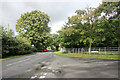
B5081 Crown Lane junction with Foxcovert Lane
Image: © Peter Turner
Taken: 29 Sep 2012
0.22 miles
2
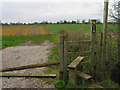
Path across the fields, Lower Peover
Path from Mill Bank Farm, Lower Peover to Swan Green. The collapsed gate renders the stile almost redundant.
Image: © Ian Nadin
Taken: 12 Dec 2006
0.23 miles