IMAGES TAKEN NEAR TO
London Road, KNUTSFORD, WA16 9LL
Introduction
This page details the photographs taken nearby to London Road, WA16 9LL by members of the Geograph project.
The Geograph project started in 2005 with the aim of publishing, organising and preserving representative images for every square kilometre of Great Britain, Ireland and the Isle of Man.

There are currently over 7.5m images from over14,400 individuals and you can help contribute to the project by visiting https://www.geograph.org.uk
Image Map
Images are licensed for reuse under creativecommons.org/licenses/by-sa/2.0
Notes
- Clicking on the map will re-center to the selected point.
- The higher the marker number, the further away the image location is from the centre of the postcode.
Image Listing (16 Images Found)
Images are licensed for reuse under creativecommons.org/licenses/by-sa/2.0
Image
Details
Distance
1
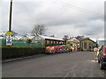
Hills Garden Centre - Car Park & Small Train Ride
Hills garden centre features two ride-on railways. In the distance is the "station" for one of two such rides at the Allostock site. Highly recommended for children of all ages.
Image: © Peter Whatley
Taken: 13 Mar 2009
0.01 miles
2
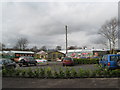
Hills Garden Centre - Entrance and Main Buildings
Image: © Peter Whatley
Taken: 13 Mar 2009
0.02 miles
4
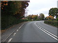
Bend in the A50, Allostock
Heading north east towards Knutsford.
Image: © JThomas
Taken: 29 Oct 2016
0.03 miles
5
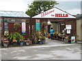
Welcome to Hills
A friendly local garden centre with lots of distractions for the younger members of the family.
Image: © Whatlep
Taken: 30 Jul 2008
0.03 miles
6
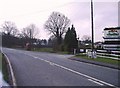
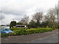
Telephone Box and Garden Centre, Allostock Cheshire
The telephone box in the village of Allostock appears to be a major feature on the O.S. map, whilst in reality, the garden centre catches the eye of the passing motorist.
Image: © R Greenhalgh
Taken: 24 Mar 2007
0.06 miles
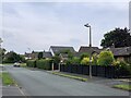
9
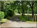
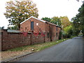
Sandy Lane, north from Wash Lane
Sandy Lane is a public byway.
Image: © Stephen Craven
Taken: 26 Jun 2021
0.13 miles